Liaocheng geodata
Liaocheng (Shandong) is a seat of a second-order administrative division; located in China in Asia/Shanghai (GMT+8) time zone. With population of 226,930 people, there are 211 cities with bigger population in this country. Compared to other cities in China, 78.2% of cities are located further ↓South; 59.9% of cities are located further ←West and 74.1% of cities have higher elevation than Liaocheng. Note1


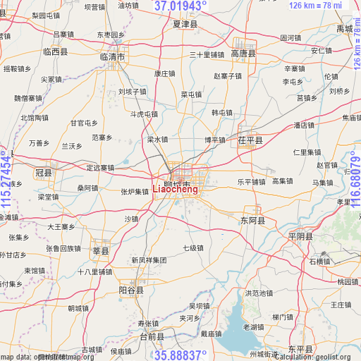
Liaocheng GPS coordinates[2]
36° 27' 21.456" North, 115° 58' 39.576" East
| Map corner | latitude | longitude |
|---|---|---|
| Upper-left | 37.01943°, | 115.27454° |
| Center: | 36.45596°, | 115.97766° |
| Lower-right: | 35.88837°, | 116.68079° |
| Map W x H: | 125.8×125.8 km | = 78.2×78.2mi |
| max Lat: | 53.31946° ⇑21.8% North |
| Liaocheng: | 36.45596° |
| min Lat: | ⇓78.2% South 18.22056° |
| min Long | Liaocheng | max Long |
| 75.07348° | 115.97766° | 134.28917° |
| W 59.9%⇐ | ⇒40.1% E |
Elevation
Elevation of Liaocheng is 39 m = 128 ft, and this is 445.8 m = 1463 ft below average elevation for this country.
| Max E: |
5622 m = 18445 ft | 74.1% |
| Avg. | 484.8 m = 1591 ft | |
| Liaocheng | 39 m = 128 ft | |
Min E: |
-3 m = -10 ft | 25.9% |
See also: Liaocheng elevation on elevation.city.
Geographical zone
Liaocheng is located in North temperate zone (between Tropic of Cancer and the Arctic Circle). Distance of this Northern Tropic circle is 1447.6 km =899.5 mi to South.| Distance of | km | miles | from Liaocheng |
|---|---|---|---|
| North Pole | 5953.5 | 3699.3 | to North |
| Arctic Circle | 3347.7 | 2080.2 | to North |
| Tropic Cancer | 1447.6 | 899.5 | to South |
| Equator | 4053.5 | 2518.7 | to South |


Nearby cities:
15 places around Liaocheng: (largest is in red/bold)
• Changqing
67.9 km =42.2 mi,  80°
80°
• Dongluqiao
62.2 km =38.6 mi,  293°
293°
• Gaobeijie
51.9 km =32.2 mi,  329°
329°
• Guancheng
48.6 km =30.2 mi,  273°
273°
• Guantao
62.8 km =39 mi,  278°
278°
• Gulou
1.8 km =1.1 mi,  222°
222°
• Liuzhuang
63.6 km =39.5 mi,  343°
343°
• Nancheng
54.8 km =34.1 mi,  1°
1°
• Pingyin
46.1 km =28.6 mi,  114°
114°
• Qingnian
48.9 km =30.4 mi, 330°
• Xiying
61.1 km =38 mi, 269°
• Yanggu
42.5 km =26.4 mi,  205°
205°
• Yanta
36.7 km =22.8 mi,  229°
229°
• Youfang
64.5 km =40.1 mi, 343°
• Zhoucheng
67.5 km =41.9 mi,  153°
153°
Sources, notices
• [Note1] Compared only with cities in China existing in our database
• [Src1] Map data: © OpenStreetMap contributors (CC-BY-SA)
• [Src2] Other city data from geonames.org with taken over terms of usage.
• [Src3] Geographical zone / Annual Mean Temperature by Robert A. Rohde @ Wikipedia
