Xingtai geodata
Xingtai (Hebei) is a populated place; located in China in Asia/Shanghai (GMT+8) time zone. With population of 611,739 people, there are 107 cities with bigger population in this country. Compared to other cities in China, 79.3% of cities are located further ↓South; 51.5% of cities are located further ←West and 64.3% of cities have higher elevation than Xingtai. Note1


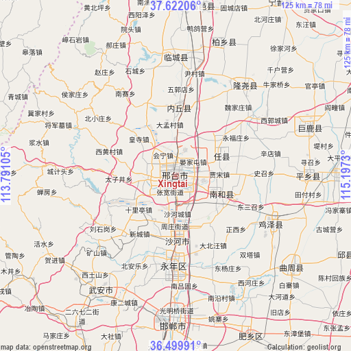
Xingtai GPS coordinates[2]
37° 3' 47.016" North, 114° 29' 39.012" East
| Map corner | latitude | longitude |
|---|---|---|
| Upper-left | 37.62206°, | 113.79105° |
| Center: | 37.06306°, | 114.49417° |
| Lower-right: | 36.49991°, | 115.1973° |
| Map W x H: | 124.8×124.8 km | = 77.5×77.5mi |
| max Lat: | 53.31946° ⇑20.7% North |
| Xingtai: | 37.06306° |
| min Lat: | ⇓79.3% South 18.22056° |
| min Long | Xingtai | max Long |
| 75.07348° | 114.49417° | 134.28917° |
| W 51.5%⇐ | ⇒48.5% E |
Elevation
Elevation of Xingtai is 76 m = 249 ft, and this is 408.8 m = 1341 ft below average elevation for this country.
| Max E: |
5622 m = 18445 ft | 64.3% |
| Avg. | 484.8 m = 1591 ft | |
| Xingtai | 76 m = 249 ft | |
Min E: |
-3 m = -10 ft | 35.7% |
See also: Xingtai elevation on elevation.city.
Geographical zone
Xingtai is located in North temperate zone (between Tropic of Cancer and the Arctic Circle). Distance of this Northern Tropic circle is 1515.1 km =941.4 mi to South.| Distance of | km | miles | from Xingtai |
|---|---|---|---|
| North Pole | 5886 | 3657.4 | to North |
| Arctic Circle | 3280.1 | 2038.2 | to North |
| Tropic Cancer | 1515.1 | 941.4 | to South |
| Equator | 4121 | 2560.7 | to South |


Nearby cities:
15 places around Xingtai: (largest is in red/bold)
• Chensan
67.5 km =41.9 mi,  122°
122°
• Dongliang’erzhuang
77.3 km =48 mi, 118°
• Dongluqiao
86.4 km =53.7 mi, 119°
• Guantao
91.1 km =56.6 mi,  129°
129°
• Handan
51.5 km =32 mi,  182°
182°
• Hecun
68.1 km =42.3 mi,  210°
210°
• Linshui
75.5 km =46.9 mi,  199°
199°
• Luancheng
91.8 km =57 mi,  8°
8°
• Mingzhou
68.4 km =42.5 mi,  98°
98°
• Nangong
84.6 km =52.6 mi,  67°
67°
• Pengcheng
76 km =47.2 mi, 202°
• Qiangezhai
79.3 km =49.3 mi, 98°
• Shahecheng
13.9 km =8.6 mi, 175°
• Xinmatou
66 km =41 mi,  114°
114°
• Yixing
89.9 km =55.9 mi,  289°
289°
Sources, notices
• [Note1] Compared only with cities in China existing in our database
• [Src1] Map data: © OpenStreetMap contributors (CC-BY-SA)
• [Src2] Other city data from geonames.org with taken over terms of usage.
• [Src3] Geographical zone / Annual Mean Temperature by Robert A. Rohde @ Wikipedia
