Handan geodata
Handan (Hebei) is a populated place; located in China in Asia/Shanghai (GMT+8) time zone. With population of 1,358,318 people, there are 51 cities with bigger population in this country. Compared to other cities in China, 78.4% of cities are located further ↓South; 51.4% of cities are located further ←West and 66.6% of cities have higher elevation than Handan. Note1


Handan GPS coordinates[2]
36° 36' 2.016" North, 114° 28' 4.008" East
| Map corner | latitude | longitude |
|---|---|---|
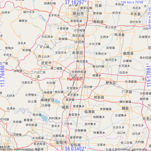
| Upper-left | 37.16297°, | 113.76466° |
| Center: | 36.60056°, | 114.46778° |
| Lower-right: | 36.03402°, | 115.17091° |
| Map W x H: | 125.5×125.5 km | = 78×78mi |
| max Lat: | 53.31946° ⇑21.6% North |
| Handan: | 36.60056° |
| min Lat: | ⇓78.4% South 18.22056° |
| min Long | Handan | max Long |
| 75.07348° | 114.46778° | 134.28917° |
| W 51.4%⇐ | ⇒48.6% E |
Elevation
Elevation of Handan is 66 m = 217 ft, and this is 418.8 m = 1374 ft below average elevation for this country.
| Max E: |
5622 m = 18445 ft | 66.6% |
| Avg. | 484.8 m = 1591 ft | |
| Handan | 66 m = 217 ft | |
Min E: |
-3 m = -10 ft | 33.4% |
See also: Handan elevation on elevation.city.
Geographical zone
Handan is located in North temperate zone (between Tropic of Cancer and the Arctic Circle). Distance of this Northern Tropic circle is 1463.7 km =909.5 mi to South.| Distance of | km | miles | from Handan |
|---|---|---|---|
| North Pole | 5937.5 | 3689.4 | to North |
| Arctic Circle | 3331.6 | 2070.2 | to North |
| Tropic Cancer | 1463.7 | 909.5 | to South |
| Equator | 4069.6 | 2528.7 | to South |


Nearby cities:
15 places around Handan: (largest is in red/bold)
• Anyang
56.6 km =35.2 mi,  187°
187°
• Chensan
61.3 km =38.1 mi,  75°
75°
• Daming
69.8 km =43.4 mi,  120°
120°
• Dongliang’erzhuang
71.7 km =44.6 mi, 78°
• Dongluqiao
78.4 km =48.7 mi, 83°
• Guantao
73.1 km =45.4 mi,  95°
95°
• Hecun
32.7 km =20.3 mi,  256°
256°
• Linshui
30.6 km =19 mi,  230°
230°
• Mingzhou
81.7 km =50.8 mi,  59°
59°
• Pengcheng
32.6 km =20.3 mi, 234°
• Shahecheng
37.7 km =23.4 mi,  5°
5°
• Tangyang Chengguanzhen
77 km =47.8 mi, 187°
• Xingtai
51.5 km =32 mi,  2°
2°
• Xinmatou
67.1 km =41.7 mi,  68°
68°
• Xiying
75.8 km =47.1 mi, 102°
Sources, notices
• [Note1] Compared only with cities in China existing in our database
• [Src1] Map data: © OpenStreetMap contributors (CC-BY-SA)
• [Src2] Other city data from geonames.org with taken over terms of usage.
• [Src3] Geographical zone / Annual Mean Temperature by Robert A. Rohde @ Wikipedia
