Shiqian geodata
Shiqian (Guizhou) is a populated place; located in China in Asia/Shanghai (GMT+8) time zone. With population of 9,571 people, there are 815 cities with bigger population in this country. Compared to other cities in China, 76.5% of cities are located further ↑North; 79.7% of cities are located further →East and 73.1% of cities have lower elevation than Shiqian. Note1


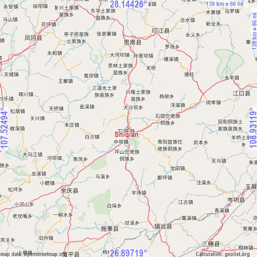
Shiqian GPS coordinates[2]
27° 31' 21" North, 108° 13' 41.016" East
| Map corner | latitude | longitude |
|---|---|---|
| Upper-left | 28.14428°, | 107.52494° |
| Center: | 27.5225°, | 108.22806° |
| Lower-right: | 26.89719°, | 108.93119° |
| Map W x H: | 138.7×138.7 km | = 86.2×86.2mi |
| max Lat: | 53.31946° ⇑76.5% North |
| Shiqian: | 27.5225° |
| min Lat: | ⇓23.5% South 18.22056° |
| min Long | Shiqian | max Long |
| 75.07348° | 108.22806° | 134.28917° |
| W 20.3%⇐ | ⇒79.7% E |
Elevation
Elevation of Shiqian is 477 m = 1565 ft, and this is 7.8 m = 26 ft below average elevation for this country.
| Max E: |
5622 m = 18445 ft | 26.9% |
| Avg. | 484.8 m = 1591 ft | |
| Shiqian | 477 m = 1565 ft | |
Min E: |
-3 m = -10 ft | 73.1% |
See also: China elevation on elevation.city.
Geographical zone
Shiqian is located in North temperate zone (between Tropic of Cancer and the Arctic Circle). Distance of this Northern Tropic circle is 454.3 km =282.3 mi to South.| Distance of | km | miles | from Shiqian |
|---|---|---|---|
| North Pole | 6946.8 | 4316.5 | to North |
| Arctic Circle | 4341 | 2697.4 | to North |
| Tropic Cancer | 454.3 | 282.3 | to South |
| Equator | 3060.2 | 1901.5 | to South |


Nearby cities:
15 places around Shiqian: (largest is in red/bold)
• Banxi
65.6 km =40.8 mi,  21°
21°
• Chaodi
64.4 km =40 mi,  0°
0°
• Dabachang
27 km =16.8 mi, 24°
• Donghua
63.5 km =39.5 mi,  347°
347°
• Duping
32.8 km =20.4 mi,  143°
143°
• Eling
55.8 km =34.7 mi, 17°
• Jiaoxi
58.2 km =36.2 mi,  146°
146°
• Kuanping
59.6 km =37 mi,  339°
339°
• Langxi
59.7 km =37.1 mi, 24°
• Minhe
53.9 km =33.5 mi,  88°
88°
• Siyang
61.6 km =38.3 mi,  124°
124°
• Xujiaba
41.8 km =26 mi, 344°
• Yangliugou
56.2 km =34.9 mi,  96°
96°
• Yongxi
57.7 km =35.9 mi,  169°
169°
• Zhongba
56.9 km =35.4 mi,  10°
10°
Sources, notices
• [Note1] Compared only with cities in China existing in our database
• [Src1] Map data: © OpenStreetMap contributors (CC-BY-SA)
• [Src2] Other city data from geonames.org with taken over terms of usage.
• [Src3] Geographical zone / Annual Mean Temperature by Robert A. Rohde @ Wikipedia
