Gaocheng geodata
Gaocheng (Sichuan) is a seat of a third-order administrative division; located in China in Asia/Shanghai (GMT+8) time zone. In our database, there are 1268 cities with bigger population. Compared to other cities in China, 54.2% of cities are located further ↑North; 94.3% of cities are located further →East and 98.5% of cities have lower elevation than Gaocheng. Note1


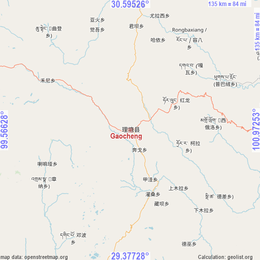
Gaocheng GPS coordinates[2]
29° 59' 17.304" North, 100° 16' 9.84" East
| Map corner | latitude | longitude |
|---|---|---|
| Upper-left | 30.59526°, | 99.56628° |
| Center: | 29.98814°, | 100.2694° |
| Lower-right: | 29.37728°, | 100.97253° |
| Map W x H: | 135.4×135.4 km | = 84.1×84.1mi |
| max Lat: | 53.31946° ⇑54.2% North |
| Gaocheng: | 29.98814° |
| min Lat: | ⇓45.8% South 18.22056° |
| min Long | Gaocheng | max Long |
| 75.07348° | 100.2694° | 134.28917° |
| W 5.7%⇐ | ⇒94.3% E |
Elevation
Elevation of Gaocheng is 3935 m = 12910 ft, and this is 3450.2 m = 11320 ft above average elevation for this country.
| Max E: |
5622 m = 18445 ft | 1.5% |
| Gaocheng | 3935 m 12910 ft | |
| Avg. | 484.8 m = 1591 ft | |
Min E: |
-3 m = -10 ft | 98.5% |
See also: China elevation on elevation.city.
Geographical zone
Gaocheng is located in North temperate zone (between Tropic of Cancer and the Arctic Circle). Distance of this Northern Tropic circle is 728.4 km =452.6 mi to South.| Distance of | km | miles | from Gaocheng |
|---|---|---|---|
| North Pole | 6672.7 | 4146.2 | to North |
| Arctic Circle | 4066.8 | 2527 | to North |
| Tropic Cancer | 728.4 | 452.6 | to South |
| Equator | 3334.4 | 2071.9 | to South |


Nearby cities:
15 places around Gaocheng: (largest is in red/bold)
• Baiyu
167.3 km =104 mi,  200°
200°
• Dongwang
166.6 km =103.5 mi, 197°
• Foshan
198.9 km =123.6 mi,  225°
225°
• Ganzi
184.2 km =114.5 mi,  351°
351°
• Gartog
165 km =102.5 mi,  258°
258°
• Kangding
162.5 km =101 mi,  89°
89°
• Luqiao
189.1 km =117.5 mi, 91°
• Rulong
106 km =65.9 mi,  2°
2°
• Sangpi
125.7 km =78.1 mi, 201°
• Songmai
170.7 km =106.1 mi,  213°
213°
• Xianshui
138.6 km =86.1 mi,  36°
36°
• Xia’er
162.6 km =101 mi,  132°
132°
• Xindou
161.4 km =100.3 mi,  14°
14°
• Yangla
160.5 km =99.7 mi,  223°
223°
• Zhanggu
183.5 km =114 mi,  57°
57°
Sources, notices
• [Note1] Compared only with cities in China existing in our database
• [Src1] Map data: © OpenStreetMap contributors (CC-BY-SA)
• [Src2] Other city data from geonames.org with taken over terms of usage.
• [Src3] Geographical zone / Annual Mean Temperature by Robert A. Rohde @ Wikipedia
