Dehui geodata
Dehui (Jilin) is a populated place; located in China in Asia/Shanghai (GMT+8) time zone. With population of 108,818 people, there are 404 cities with bigger population in this country. Compared to other cities in China, 93.4% of cities are located further ↓South; 95.2% of cities are located further ←West and 51.9% of cities have lower elevation than Dehui. Note1


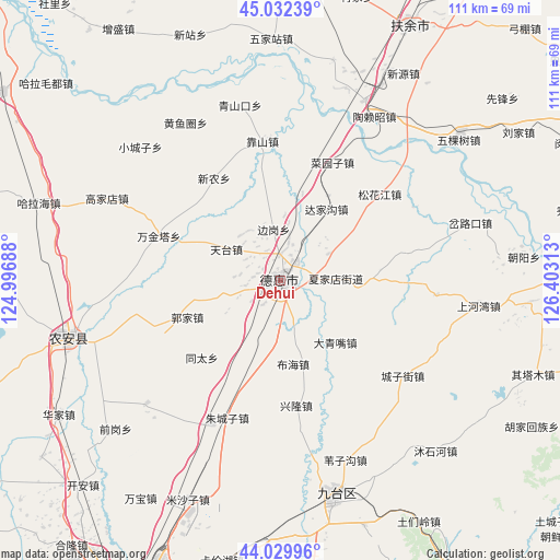
Dehui GPS coordinates[2]
44° 31' 59.988" North, 125° 42' 0" East
| Map corner | latitude | longitude |
|---|---|---|
| Upper-left | 45.03239°, | 124.99688° |
| Center: | 44.53333°, | 125.7° |
| Lower-right: | 44.02996°, | 126.40313° |
| Map W x H: | 111.5×111.5 km | = 69.3×69.3mi |
| max Lat: | 53.31946° ⇑6.6% North |
| Dehui: | 44.53333° |
| min Lat: | ⇓93.4% South 18.22056° |
| min Long | Dehui | max Long |
| 75.07348° | 125.7° | 134.28917° |
| W 95.2%⇐ | ⇒4.8% E |
Elevation
Elevation of Dehui is 180 m = 591 ft, and this is 304.8 m = 1000 ft below average elevation for this country.
| Max E: |
5622 m = 18445 ft | 48.1% |
| Avg. | 484.8 m = 1591 ft | |
| Dehui | 180 m = 591 ft | |
Min E: |
-3 m = -10 ft | 51.9% |
See also: Dehui elevation on elevation.city.
Geographical zone
Dehui is located in North temperate zone (between Tropic of Cancer and the Arctic Circle). Distance of this Northern Tropic circle is 2345.7 km =1457.5 mi to South.| Distance of | km | miles | from Dehui |
|---|---|---|---|
| North Pole | 5055.4 | 3141.3 | to North |
| Arctic Circle | 2449.5 | 1522 | to North |
| Tropic Cancer | 2345.7 | 1457.5 | to South |
| Equator | 4951.6 | 3076.8 | to South |


Nearby cities:
15 places around Dehui: (largest is in red/bold)
• Changchun
78.6 km =48.8 mi,  202°
202°
• Fuyu
100.4 km =62.4 mi,  316°
316°
• Jilin
102.3 km =63.6 mi,  137°
137°
• Jishu
90.6 km =56.3 mi,  105°
105°
• Jiutai
43.6 km =27.1 mi,  165°
165°
• Nong’an
45.4 km =28.2 mi,  248°
248°
• Qingshan
113 km =70.2 mi,  56°
56°
• Sanchahe
53.9 km =33.5 mi,  27°
27°
• Shuangcheng
101.8 km =63.3 mi, 26°
• Shuangyang
112.2 km =69.7 mi,  181°
181°
• Shulan
100 km =62.1 mi,  97°
97°
• Songyuan
95.5 km =59.3 mi,  313°
313°
• Xinglongshan
66.8 km =41.5 mi, 196°
• Yanhe
116 km =72.1 mi, 56°
• Yushu
72.3 km =44.9 mi,  65°
65°
Sources, notices
• [Note1] Compared only with cities in China existing in our database
• [Src1] Map data: © OpenStreetMap contributors (CC-BY-SA)
• [Src2] Other city data from geonames.org with taken over terms of usage.
• [Src3] Geographical zone / Annual Mean Temperature by Robert A. Rohde @ Wikipedia
