Jiutai geodata
Jiutai (Jilin) is a populated place; located in China in Asia/Shanghai (GMT+8) time zone. With population of 175,115 people, there are 256 cities with bigger population in this country. Compared to other cities in China, 93% of cities are located further ↓South; 95.3% of cities are located further ←West and 51.9% of cities have lower elevation than Jiutai. Note1


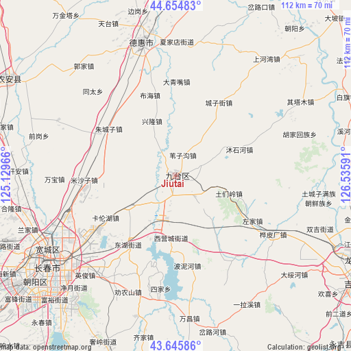
Jiutai GPS coordinates[2]
44° 9' 9" North, 125° 49' 58.008" East
| Map corner | latitude | longitude |
|---|---|---|
| Upper-left | 44.65483°, | 125.12966° |
| Center: | 44.1525°, | 125.83278° |
| Lower-right: | 43.64586°, | 126.53591° |
| Map W x H: | 112.2×112.2 km | = 69.7×69.7mi |
| max Lat: | 53.31946° ⇑7% North |
| Jiutai: | 44.1525° |
| min Lat: | ⇓93% South 18.22056° |
| min Long | Jiutai | max Long |
| 75.07348° | 125.83278° | 134.28917° |
| W 95.3%⇐ | ⇒4.7% E |
Elevation
Elevation of Jiutai is 180 m = 591 ft, and this is 304.8 m = 1000 ft below average elevation for this country.
| Max E: |
5622 m = 18445 ft | 48.1% |
| Avg. | 484.8 m = 1591 ft | |
| Jiutai | 180 m = 591 ft | |
Min E: |
-3 m = -10 ft | 51.9% |
See also: Jiutai elevation on elevation.city.
Geographical zone
Jiutai is located in North temperate zone (between Tropic of Cancer and the Arctic Circle). Distance of this Northern Tropic circle is 2303.4 km =1431.3 mi to South.| Distance of | km | miles | from Jiutai |
|---|---|---|---|
| North Pole | 5097.8 | 3167.6 | to North |
| Arctic Circle | 2491.9 | 1548.4 | to North |
| Tropic Cancer | 2303.4 | 1431.3 | to South |
| Equator | 4909.3 | 3050.5 | to South |


Nearby cities:
15 places around Jiutai: (largest is in red/bold)
• Changchun
50.8 km =31.6 mi,  233°
233°
• Dehui
43.6 km =27.1 mi,  345°
345°
• Gongzhuling
108.9 km =67.7 mi, 228°
• Jilin
67.2 km =41.8 mi,  119°
119°
• Jishu
79.2 km =49.2 mi,  76°
76°
• Kouqian
75.9 km =47.2 mi,  138°
138°
• Nong’an
58.7 km =36.5 mi,  295°
295°
• Sanchahe
91.3 km =56.7 mi,  9°
9°
• Shuangyang
71 km =44.1 mi,  190°
190°
• Shulan
93.7 km =58.2 mi,  71°
71°
• Xinglongshan
36.5 km =22.7 mi, 233°
• Xin’an
122.8 km =76.3 mi, 84°
• Yantongshan
96.7 km =60.1 mi,  171°
171°
• Yitong
101.4 km =63 mi,  205°
205°
• Yushu
91 km =56.5 mi,  37°
37°
Sources, notices
• [Note1] Compared only with cities in China existing in our database
• [Src1] Map data: © OpenStreetMap contributors (CC-BY-SA)
• [Src2] Other city data from geonames.org with taken over terms of usage.
• [Src3] Geographical zone / Annual Mean Temperature by Robert A. Rohde @ Wikipedia
