Lumaka geodata
Lumaka (Tibet) is a seat of a fourth-order administrative division; located in China in Asia/Shanghai (GMT+8) time zone. In our database, there are 1268 cities with bigger population. Compared to other cities in China, 66.5% of cities are located further ↓South; 99.5% of cities are located further →East and 99.4% of cities have lower elevation than Lumaka. Note1


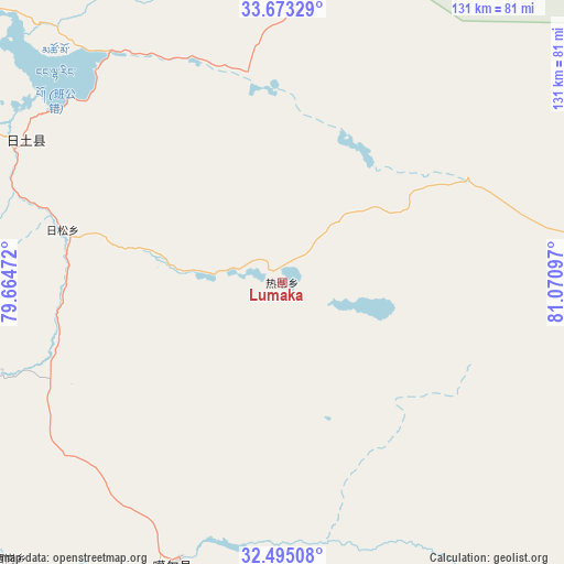
Lumaka GPS coordinates[2]
33° 5' 10.176" North, 80° 22' 4.224" East
| Map corner | latitude | longitude |
|---|---|---|
| Upper-left | 33.67329°, | 79.66472° |
| Center: | 33.08616°, | 80.36784° |
| Lower-right: | 32.49508°, | 81.07097° |
| Map W x H: | 131×131 km | = 81.4×81.4mi |
| max Lat: | 53.31946° ⇑33.5% North |
| Lumaka: | 33.08616° |
| min Lat: | ⇓66.5% South 18.22056° |
| min Long | Lumaka | max Long |
| 75.07348° | 80.36784° | 134.28917° |
| W 0.5%⇐ | ⇒99.5% E |
Elevation
Elevation of Lumaka is 4349 m = 14268 ft, and this is 3864.2 m = 12678 ft above average elevation for this country.
| Max E: |
5622 m = 18445 ft | 0.59999999999999% |
| Lumaka | 4349 m 14268 ft | |
| Avg. | 484.8 m = 1591 ft | |
Min E: |
-3 m = -10 ft | 99.4% |
See also: China elevation on elevation.city.
Geographical zone
Lumaka is located in North temperate zone (between Tropic of Cancer and the Arctic Circle). Distance of this Northern Tropic circle is 1072.9 km =666.7 mi to South.| Distance of | km | miles | from Lumaka |
|---|---|---|---|
| North Pole | 6328.2 | 3932.2 | to North |
| Arctic Circle | 3722.3 | 2312.9 | to North |
| Tropic Cancer | 1072.9 | 666.7 | to South |
| Equator | 3678.8 | 2285.9 | to South |


Nearby cities:
15 places around Lumaka: (largest is in red/bold)
• Burang
319.5 km =198.5 mi,  166°
166°
• Darchen
254.9 km =158.4 mi,  160°
160°
• Diyag
213.1 km =132.4 mi,  223°
223°
• Gangsha
250 km =155.3 mi, 159°
• Gar
111.4 km =69.2 mi,  195°
195°
• Geji
105.4 km =65.5 mi,  136°
136°
• Jisegumen
115 km =71.5 mi,  18°
18°
• Langjiu
81 km =50.3 mi,  176°
176°
• Qumudi
148.2 km =92.1 mi,  228°
228°
• Rutog
77.2 km =48 mi,  298°
298°
• Shiquanhe
69.8 km =43.4 mi, 201°
• Toding
186.4 km =115.8 mi, 196°
• Xagmakajor
255.8 km =158.9 mi,  133°
133°
• Zangkaxa
69.7 km =43.3 mi,  0°
0°
• Zhabu
273.5 km =169.9 mi,  89°
89°
Sources, notices
• [Note1] Compared only with cities in China existing in our database
• [Src1] Map data: © OpenStreetMap contributors (CC-BY-SA)
• [Src2] Other city data from geonames.org with taken over terms of usage.
• [Src3] Geographical zone / Annual Mean Temperature by Robert A. Rohde @ Wikipedia
