Shiquanhe geodata
Shiquanhe (Tibet) is a seat of a second-order administrative division; located in China in Asia/Shanghai (GMT+8) time zone. In our database, there are 1268 cities with bigger population. Compared to other cities in China, 64% of cities are located further ↓South; 99.5% of cities are located further →East and 99.2% of cities have lower elevation than Shiquanhe. Note1


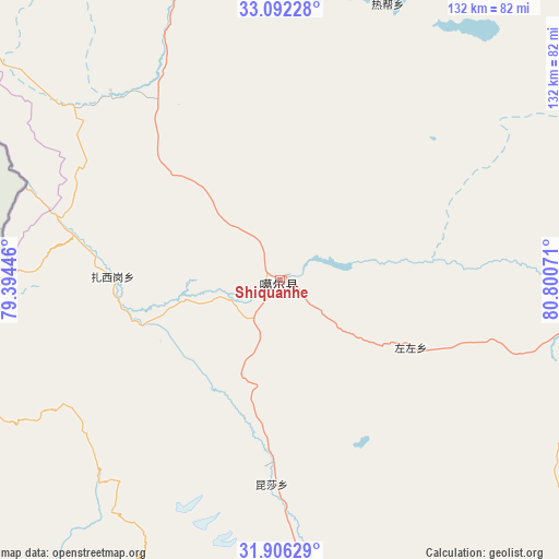
Shiquanhe GPS coordinates[2]
32° 30' 4.464" North, 80° 5' 51.288" East
| Map corner | latitude | longitude |
|---|---|---|
| Upper-left | 33.09228°, | 79.39446° |
| Center: | 32.50124°, | 80.09758° |
| Lower-right: | 31.90629°, | 80.80071° |
| Map W x H: | 131.9×131.9 km | = 82×82mi |
| max Lat: | 53.31946° ⇑36% North |
| Shiquanhe: | 32.50124° |
| min Lat: | ⇓64% South 18.22056° |
| min Long | Shiquanhe | max Long |
| 75.07348° | 80.09758° | 134.28917° |
| W 0.5%⇐ | ⇒99.5% E |
Elevation
Elevation of Shiquanhe is 4278 m = 14035 ft, and this is 3793.2 m = 12445 ft above average elevation for this country.
| Max E: |
5622 m = 18445 ft | 0.8% |
| Shiquanhe | 4278 m 14035 ft | |
| Avg. | 484.8 m = 1591 ft | |
Min E: |
-3 m = -10 ft | 99.2% |
See also: China elevation on elevation.city.
Geographical zone
Shiquanhe is located in North temperate zone (between Tropic of Cancer and the Arctic Circle). Distance of this Northern Tropic circle is 1007.9 km =626.3 mi to South.| Distance of | km | miles | from Shiquanhe |
|---|---|---|---|
| North Pole | 6393.3 | 3972.6 | to North |
| Arctic Circle | 3787.4 | 2353.4 | to North |
| Tropic Cancer | 1007.9 | 626.3 | to South |
| Equator | 3613.8 | 2245.5 | to South |


Nearby cities:
15 places around Shiquanhe: (largest is in red/bold)
• Burang
265.7 km =165.1 mi,  157°
157°
• Darchen
207.8 km =129.1 mi,  147°
147°
• Diyag
151.2 km =94 mi,  233°
233°
• Gangsha
203.4 km =126.4 mi, 146°
• Gar
42.6 km =26.5 mi,  185°
185°
• Geji
98.5 km =61.2 mi,  96°
96°
• Jisegumen
184.7 km =114.8 mi,  19°
19°
• Langjiu
34.7 km =21.6 mi,  117°
117°
• Lumaka
69.8 km =43.4 mi, 21°
• Qumudi
92 km =57.2 mi,  248°
248°
• Rutog
110.6 km =68.7 mi,  337°
337°
• Toding
117 km =72.7 mi, 193°
• Xagmakajor
238.6 km =148.3 mi, 117°
• Zangkaxa
137.2 km =85.3 mi,  10°
10°
• Zhabu
307.4 km =191 mi,  77°
77°
Sources, notices
• [Note1] Compared only with cities in China existing in our database
• [Src1] Map data: © OpenStreetMap contributors (CC-BY-SA)
• [Src2] Other city data from geonames.org with taken over terms of usage.
• [Src3] Geographical zone / Annual Mean Temperature by Robert A. Rohde @ Wikipedia
