Rutog geodata
Rutog (Tibet) is a seat of a third-order administrative division; located in China in Asia/Shanghai (GMT+8) time zone. In our database, there are 1268 cities with bigger population. Compared to other cities in China, 67.8% of cities are located further ↓South; 99.6% of cities are located further →East and 99.1% of cities have lower elevation than Rutog. Note1


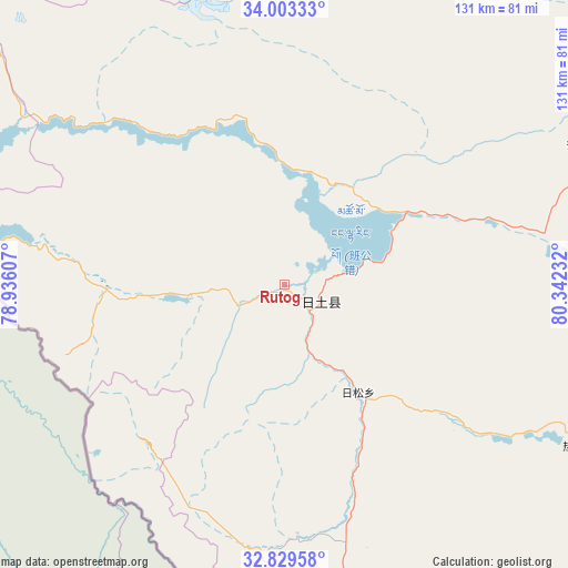
Rutog GPS coordinates[2]
33° 25' 6.384" North, 79° 38' 21.084" East
| Map corner | latitude | longitude |
|---|---|---|
| Upper-left | 34.00333°, | 78.93607° |
| Center: | 33.41844°, | 79.63919° |
| Lower-right: | 32.82958°, | 80.34232° |
| Map W x H: | 130.5×130.5 km | = 81.1×81.1mi |
| max Lat: | 53.31946° ⇑32.2% North |
| Rutog: | 33.41844° |
| min Lat: | ⇓67.8% South 18.22056° |
| min Long | Rutog | max Long |
| 75.07348° | 79.63919° | 134.28917° |
| W 0.4%⇐ | ⇒99.6% E |
Elevation
Elevation of Rutog is 4253 m = 13953 ft, and this is 3768.2 m = 12363 ft above average elevation for this country.
| Max E: |
5622 m = 18445 ft | 0.90000000000001% |
| Rutog | 4253 m 13953 ft | |
| Avg. | 484.8 m = 1591 ft | |
Min E: |
-3 m = -10 ft | 99.1% |
See also: China elevation on elevation.city.
Geographical zone
Rutog is located in North temperate zone (between Tropic of Cancer and the Arctic Circle). Distance of this Northern Tropic circle is 1109.9 km =689.7 mi to South.| Distance of | km | miles | from Rutog |
|---|---|---|---|
| North Pole | 6291.3 | 3909.2 | to North |
| Arctic Circle | 3685.4 | 2290 | to North |
| Tropic Cancer | 1109.9 | 689.7 | to South |
| Equator | 3715.8 | 2308.9 | to South |


Nearby cities:
15 places around Rutog: (largest is in red/bold)
• Darchen
317.2 km =197.1 mi,  150°
150°
• Diyag
206.6 km =128.4 mi,  202°
202°
• Gangsha
312.6 km =194.2 mi, 150°
• Gar
149.6 km =93 mi,  164°
164°
• Geji
180.4 km =112.1 mi,  129°
129°
• Jisegumen
126.9 km =78.9 mi,  55°
55°
• Langjiu
138.8 km =86.2 mi, 148°
• Lumaka
77.2 km =48 mi,  118°
118°
• Nur
348.1 km =216.3 mi,  21°
21°
• Qumudi
141.9 km =88.2 mi, 197°
• Shiquanhe
110.6 km =68.7 mi, 157°
• Toding
216 km =134.2 mi,  176°
176°
• Xagmakajor
331.1 km =205.7 mi, 130°
• Zangkaxa
75.8 km =47.1 mi, 64°
• Zhabu
342.3 km =212.7 mi,  95°
95°
Sources, notices
• [Note1] Compared only with cities in China existing in our database
• [Src1] Map data: © OpenStreetMap contributors (CC-BY-SA)
• [Src2] Other city data from geonames.org with taken over terms of usage.
• [Src3] Geographical zone / Annual Mean Temperature by Robert A. Rohde @ Wikipedia
