Zhadong geodata
Zhadong (Tibet) is a seat of a third-order administrative division; located in China in Asia/Shanghai (GMT+8) time zone. In our database, there are 1268 cities with bigger population. Compared to other cities in China, 58% of cities are located further ↑North; 98.8% of cities are located further →East and 99.6% of cities have lower elevation than Zhadong. Note1


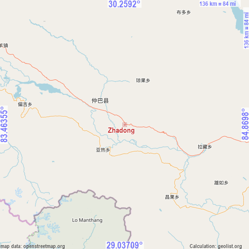
Zhadong GPS coordinates[2]
29° 39' 0" North, 84° 10' 0.012" East
| Map corner | latitude | longitude |
|---|---|---|
| Upper-left | 30.2592°, | 83.46355° |
| Center: | 29.65°, | 84.16667° |
| Lower-right: | 29.03709°, | 84.8698° |
| Map W x H: | 135.9×135.9 km | = 84.4×84.4mi |
| max Lat: | 53.31946° ⇑58% North |
| Zhadong: | 29.65° |
| min Lat: | ⇓42% South 18.22056° |
| min Long | Zhadong | max Long |
| 75.07348° | 84.16667° | 134.28917° |
| W 1.2%⇐ | ⇒98.8% E |
Elevation
Elevation of Zhadong is 4559 m = 14957 ft, and this is 4074.2 m = 13367 ft above average elevation for this country.
| Max E: |
5622 m = 18445 ft | 0.40000000000001% |
| Zhadong | 4559 m 14957 ft | |
| Avg. | 484.8 m = 1591 ft | |
Min E: |
-3 m = -10 ft | 99.6% |
See also: China elevation on elevation.city.
Geographical zone
Zhadong is located in North temperate zone (between Tropic of Cancer and the Arctic Circle). Distance of this Northern Tropic circle is 690.9 km =429.3 mi to South.| Distance of | km | miles | from Zhadong |
|---|---|---|---|
| North Pole | 6710.3 | 4169.6 | to North |
| Arctic Circle | 4104.4 | 2550.4 | to North |
| Tropic Cancer | 690.9 | 429.3 | to South |
| Equator | 3296.8 | 2048.5 | to South |


Nearby cities:
15 places around Zhadong: (largest is in red/bold)
• Burang
296.9 km =184.5 mi,  283°
283°
• Camgyai
277.2 km =172.2 mi,  131°
131°
• Chongdui
241.9 km =150.3 mi, 133°
• Darchen
310.8 km =193.1 mi,  297°
297°
• Gangsha
313.3 km =194.7 mi, 298°
• Luring
291 km =180.8 mi,  0°
0°
• Maindong
222.2 km =138.1 mi,  32°
32°
• Ngamring
294.2 km =182.8 mi,  99°
99°
• Quxar
343 km =213.1 mi, 100°
• Saga
108.8 km =67.6 mi,  109°
109°
• Xagmakajor
270 km =167.8 mi,  319°
319°
• Xêgar
305 km =189.5 mi, 111°
• Zham
256.2 km =159.2 mi,  136°
136°
• Zongga
127.5 km =79.2 mi,  124°
124°
• Zuobude
277.2 km =172.2 mi, 131°
Sources, notices
• [Note1] Compared only with cities in China existing in our database
• [Src1] Map data: © OpenStreetMap contributors (CC-BY-SA)
• [Src2] Other city data from geonames.org with taken over terms of usage.
• [Src3] Geographical zone / Annual Mean Temperature by Robert A. Rohde @ Wikipedia
