Wangda geodata
Wangda (Tibet) is a seat of a third-order administrative division; located in China in Asia/Shanghai (GMT+8) time zone. In our database, there are 1268 cities with bigger population. Compared to other cities in China, 57.8% of cities are located further ↑North; 95.5% of cities are located further →East and 98.2% of cities have lower elevation than Wangda. Note1


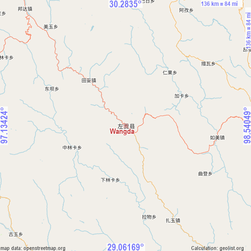
Wangda GPS coordinates[2]
29° 40' 28.02" North, 97° 50' 14.496" East
| Map corner | latitude | longitude |
|---|---|---|
| Upper-left | 30.2835°, | 97.13424° |
| Center: | 29.67445°, | 97.83736° |
| Lower-right: | 29.06169°, | 98.54049° |
| Map W x H: | 135.9×135.9 km | = 84.4×84.4mi |
| max Lat: | 53.31946° ⇑57.8% North |
| Wangda: | 29.67445° |
| min Lat: | ⇓42.2% South 18.22056° |
| min Long | Wangda | max Long |
| 75.07348° | 97.83736° | 134.28917° |
| W 4.5%⇐ | ⇒95.5% E |
Elevation
Elevation of Wangda is 3806 m = 12487 ft, and this is 3321.2 m = 10896 ft above average elevation for this country.
| Max E: |
5622 m = 18445 ft | 1.8% |
| Wangda | 3806 m 12487 ft | |
| Avg. | 484.8 m = 1591 ft | |
Min E: |
-3 m = -10 ft | 98.2% |
See also: China elevation on elevation.city.
Geographical zone
Wangda is located in North temperate zone (between Tropic of Cancer and the Arctic Circle). Distance of this Northern Tropic circle is 693.6 km =431 mi to South.| Distance of | km | miles | from Wangda |
|---|---|---|---|
| North Pole | 6707.6 | 4167.9 | to North |
| Arctic Circle | 4101.7 | 2548.7 | to North |
| Tropic Cancer | 693.6 | 431 | to South |
| Equator | 3299.5 | 2050.2 | to South |


Nearby cities:
15 places around Wangda: (largest is in red/bold)
• Baima
98.3 km =61.1 mi,  295°
295°
• Foshan
140.6 km =87.4 mi,  138°
138°
• Gartog
73.2 km =45.5 mi,  89°
89°
• Gyigang
116.3 km =72.3 mi,  195°
195°
• Jomda
205.7 km =127.8 mi,  10°
10°
• Molo
138.3 km =85.9 mi,  17°
17°
• Moluo
128.1 km =79.6 mi, 11°
• Qamdo
173.7 km =107.9 mi,  338°
338°
• Shengping
168.4 km =104.6 mi, 141°
• Songmai
176.5 km =109.7 mi,  127°
127°
• Yanduo
112.2 km =69.7 mi,  346°
346°
• Yangla
149.3 km =92.8 mi,  123°
123°
• Yunling
189.1 km =117.5 mi, 144°
• Zhamog
201.7 km =125.3 mi,  276°
276°
• Zhowagoin
119 km =73.9 mi, 198°
Sources, notices
• [Note1] Compared only with cities in China existing in our database
• [Src1] Map data: © OpenStreetMap contributors (CC-BY-SA)
• [Src2] Other city data from geonames.org with taken over terms of usage.
• [Src3] Geographical zone / Annual Mean Temperature by Robert A. Rohde @ Wikipedia
