Huanghe geodata
Huanghe (Qinghai) is a seat of a fourth-order administrative division; located in China in Asia/Shanghai (GMT+8) time zone. In our database, there are 1268 cities with bigger population. Compared to other cities in China, 73.1% of cities are located further ↓South; 95.4% of cities are located further →East and 99% of cities have lower elevation than Huanghe. Note1


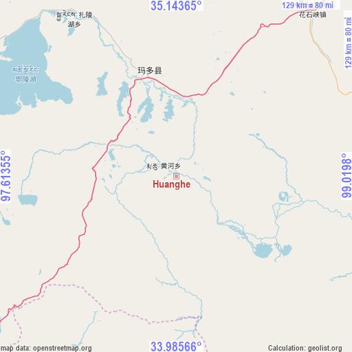
Huanghe GPS coordinates[2]
34° 34' 0.012" North, 98° 19' 0.012" East
| Map corner | latitude | longitude |
|---|---|---|
| Upper-left | 35.14365°, | 97.61355° |
| Center: | 34.56667°, | 98.31667° |
| Lower-right: | 33.98566°, | 99.0198° |
| Map W x H: | 128.8×128.8 km | = 80×80mi |
| max Lat: | 53.31946° ⇑26.9% North |
| Huanghe: | 34.56667° |
| min Lat: | ⇓73.1% South 18.22056° |
| min Long | Huanghe | max Long |
| 75.07348° | 98.31667° | 134.28917° |
| W 4.6%⇐ | ⇒95.4% E |
Elevation
Elevation of Huanghe is 4200 m = 13780 ft, and this is 3715.2 m = 12189 ft above average elevation for this country.
| Max E: |
5622 m = 18445 ft | 1% |
| Huanghe | 4200 m 13780 ft | |
| Avg. | 484.8 m = 1591 ft | |
Min E: |
-3 m = -10 ft | 99% |
See also: China elevation on elevation.city.
Geographical zone
Huanghe is located in North temperate zone (between Tropic of Cancer and the Arctic Circle). Distance of this Northern Tropic circle is 1237.5 km =768.9 mi to South.| Distance of | km | miles | from Huanghe |
|---|---|---|---|
| North Pole | 6163.6 | 3829.9 | to North |
| Arctic Circle | 3557.7 | 2210.7 | to North |
| Tropic Cancer | 1237.5 | 768.9 | to South |
| Equator | 3843.5 | 2388.2 | to South |


Nearby cities:
15 places around Huanghe: (largest is in red/bold)
• Changmahe
79.7 km =49.5 mi,  96°
96°
• Heihe
30.8 km =19.1 mi,  326°
326°
• Huashixia
75.4 km =46.9 mi,  35°
35°
• Jianshe
140 km =87 mi,  134°
134°
• Kugri
121.8 km =75.7 mi,  3°
3°
• Machali
41.5 km =25.8 mi,  349°
349°
• Qingshuihe
137.8 km =85.6 mi,  232°
232°
• Sangruma
130.4 km =81 mi,  141°
141°
• Tanglag
121.6 km =75.6 mi,  121°
121°
• Tehetu
105.7 km =65.7 mi, 134°
• Wenquan
142.5 km =88.5 mi,  59°
59°
• Xia Dawo
98.9 km =61.5 mi, 60°
• Xueshan
131.3 km =81.6 mi,  78°
78°
• Youyun
86.6 km =53.8 mi,  112°
112°
• Zhalinghu
68.7 km =42.7 mi, 327°
Sources, notices
• [Note1] Compared only with cities in China existing in our database
• [Src1] Map data: © OpenStreetMap contributors (CC-BY-SA)
• [Src2] Other city data from geonames.org with taken over terms of usage.
• [Src3] Geographical zone / Annual Mean Temperature by Robert A. Rohde @ Wikipedia
