Heihe geodata
Heihe (Qinghai) is a seat of a fourth-order administrative division; located in China in Asia/Shanghai (GMT+8) time zone. In our database, there are 1268 cities with bigger population. Compared to other cities in China, 74.2% of cities are located further ↓South; 95.4% of cities are located further →East and 99.3% of cities have lower elevation than Heihe. Note1


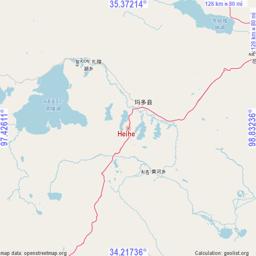
Heihe GPS coordinates[2]
34° 47' 48.372" North, 98° 7' 45.228" East
| Map corner | latitude | longitude |
|---|---|---|
| Upper-left | 35.37214°, | 97.42611° |
| Center: | 34.79677°, | 98.12923° |
| Lower-right: | 34.21736°, | 98.83236° |
| Map W x H: | 128.4×128.4 km | = 79.8×79.8mi |
| max Lat: | 53.31946° ⇑25.8% North |
| Heihe: | 34.79677° |
| min Lat: | ⇓74.2% South 18.22056° |
| min Long | Heihe | max Long |
| 75.07348° | 98.12923° | 134.28917° |
| W 4.6%⇐ | ⇒95.4% E |
Elevation
Elevation of Heihe is 4302 m = 14114 ft, and this is 3817.2 m = 12524 ft above average elevation for this country.
| Max E: |
5622 m = 18445 ft | 0.7% |
| Heihe | 4302 m 14114 ft | |
| Avg. | 484.8 m = 1591 ft | |
Min E: |
-3 m = -10 ft | 99.3% |
See also: China elevation on elevation.city.
Geographical zone
Heihe is located in North temperate zone (between Tropic of Cancer and the Arctic Circle). Distance of this Northern Tropic circle is 1263.1 km =784.9 mi to South.| Distance of | km | miles | from Heihe |
|---|---|---|---|
| North Pole | 6138 | 3814 | to North |
| Arctic Circle | 3532.1 | 2194.7 | to North |
| Tropic Cancer | 1263.1 | 784.9 | to South |
| Equator | 3869 | 2404.1 | to South |


Nearby cities:
15 places around Heihe: (largest is in red/bold)
• Barun
141.5 km =87.9 mi,  332°
332°
• Changmahe
102.3 km =63.6 mi,  109°
109°
• Huanghe
30.8 km =19.1 mi,  146°
146°
• Huashixia
70.7 km =43.9 mi,  59°
59°
• Kugri
99.2 km =61.6 mi,  14°
14°
• Machali
17.9 km =11.1 mi,  32°
32°
• Qingshuihe
143.2 km =89 mi,  219°
219°
• Tehetu
136 km =84.5 mi,  137°
137°
• Wenquan
147.3 km =91.5 mi,  71°
71°
• Xia Dawo
105.7 km =65.7 mi,  77°
77°
• Xiangjia
128.3 km =79.7 mi,  351°
351°
• Xiangride
134.9 km =83.8 mi, 350°
• Xueshan
145.8 km =90.6 mi,  90°
90°
• Youyun
113.4 km =70.5 mi,  120°
120°
• Zhalinghu
37.9 km =23.5 mi, 327°
Sources, notices
• [Note1] Compared only with cities in China existing in our database
• [Src1] Map data: © OpenStreetMap contributors (CC-BY-SA)
• [Src2] Other city data from geonames.org with taken over terms of usage.
• [Src3] Geographical zone / Annual Mean Temperature by Robert A. Rohde @ Wikipedia
