Bagan geodata
Bagan (Qinghai) is a seat of a fourth-order administrative division; located in China in Asia/Shanghai (GMT+8) time zone. In our database, there are 1268 cities with bigger population. Compared to other cities in China, 69.6% of cities are located further ↓South; 95.8% of cities are located further →East and 98.7% of cities have lower elevation than Bagan. Note1


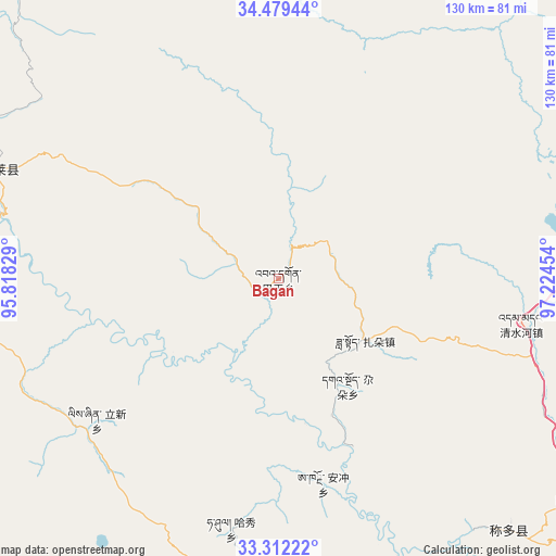
Bagan GPS coordinates[2]
33° 53' 52.188" North, 96° 31' 17.076" East
| Map corner | latitude | longitude |
|---|---|---|
| Upper-left | 34.47944°, | 95.81829° |
| Center: | 33.89783°, | 96.52141° |
| Lower-right: | 33.31222°, | 97.22454° |
| Map W x H: | 129.8×129.8 km | = 80.7×80.7mi |
| max Lat: | 53.31946° ⇑30.4% North |
| Bagan: | 33.89783° |
| min Lat: | ⇓69.6% South 18.22056° |
| min Long | Bagan | max Long |
| 75.07348° | 96.52141° | 134.28917° |
| W 4.2%⇐ | ⇒95.8% E |
Elevation
Elevation of Bagan is 4060 m = 13320 ft, and this is 3575.2 m = 11730 ft above average elevation for this country.
| Max E: |
5622 m = 18445 ft | 1.3% |
| Bagan | 4060 m 13320 ft | |
| Avg. | 484.8 m = 1591 ft | |
Min E: |
-3 m = -10 ft | 98.7% |
See also: China elevation on elevation.city.
Geographical zone
Bagan is located in North temperate zone (between Tropic of Cancer and the Arctic Circle). Distance of this Northern Tropic circle is 1163.2 km =722.8 mi to South.| Distance of | km | miles | from Bagan |
|---|---|---|---|
| North Pole | 6238 | 3876.1 | to North |
| Arctic Circle | 3632.1 | 2256.9 | to North |
| Tropic Cancer | 1163.2 | 722.8 | to South |
| Equator | 3769.1 | 2342 | to South |


Nearby cities:
15 places around Bagan: (largest is in red/bold)
• Anchong
49.2 km =30.6 mi,  167°
167°
• Dongfeng
34.5 km =21.4 mi,  308°
308°
• Duocai
102 km =63.4 mi,  264°
264°
• Gaduo
29.6 km =18.4 mi,  146°
146°
• Gyairong
70.4 km =43.7 mi,  187°
187°
• Lab
90.3 km =56.1 mi,  140°
140°
• Linxin
53.7 km =33.4 mi,  232°
232°
• Madoi
126.1 km =78.4 mi,  353°
353°
• Qigzhi
108.9 km =67.7 mi, 313°
• Qingshuihe
57.7 km =35.9 mi,  100°
100°
• Shanglaxiu
116.2 km =72.2 mi,  177°
177°
• Xiwu
114.6 km =71.2 mi, 138°
• Zadoi
24.9 km =15.5 mi,  124°
124°
• Zhiqu
104.2 km =64.7 mi,  295°
295°
• Zhoinda
90.8 km =56.4 mi, 148°
Sources, notices
• [Note1] Compared only with cities in China existing in our database
• [Src1] Map data: © OpenStreetMap contributors (CC-BY-SA)
• [Src2] Other city data from geonames.org with taken over terms of usage.
• [Src3] Geographical zone / Annual Mean Temperature by Robert A. Rohde @ Wikipedia
