Hejing geodata
Hejing (Xinjiang) is a seat of a third-order administrative division; located in China in Asia/Urumqi (GMT+6) time zone. In our database, there are 1268 cities with bigger population. Compared to other cities in China, 91.3% of cities are located further ↓South; 98.3% of cities are located further →East and 86.9% of cities have lower elevation than Hejing. Note1


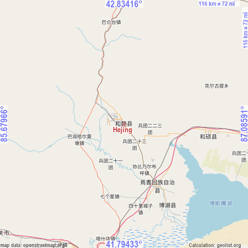
Hejing GPS coordinates[2]
42° 18' 59.004" North, 86° 22' 58.008" East
| Map corner | latitude | longitude |
|---|---|---|
| Upper-left | 42.83416°, | 85.67966° |
| Center: | 42.31639°, | 86.38278° |
| Lower-right: | 41.79433°, | 87.08591° |
| Map W x H: | 115.6×115.6 km | = 71.8×71.8mi |
| max Lat: | 53.31946° ⇑8.7% North |
| Hejing: | 42.31639° |
| min Lat: | ⇓91.3% South 18.22056° |
| min Long | Hejing | max Long |
| 75.07348° | 86.38278° | 134.28917° |
| W 1.7%⇐ | ⇒98.3% E |
Elevation
Elevation of Hejing is 1109 m = 3638 ft, and this is 624.2 m = 2048 ft above average elevation for this country.
| Max E: |
5622 m = 18445 ft | 13.1% |
| Hejing | 1109 m 3638 ft | |
| Avg. | 484.8 m = 1591 ft | |
Min E: |
-3 m = -10 ft | 86.9% |
See also: China elevation on elevation.city.
Geographical zone
Hejing is located in North temperate zone (between Tropic of Cancer and the Arctic Circle). Distance of this Northern Tropic circle is 2099.2 km =1304.4 mi to South.| Distance of | km | miles | from Hejing |
|---|---|---|---|
| North Pole | 5301.9 | 3294.4 | to North |
| Arctic Circle | 2696 | 1675.2 | to North |
| Tropic Cancer | 2099.2 | 1304.4 | to South |
| Equator | 4705.1 | 2923.6 | to South |


Nearby cities:
15 places around Hejing: (largest is in red/bold)
• Baluntaicun
39.4 km =24.5 mi,  353°
353°
• Beijinglu
194.7 km =121 mi,  29°
29°
• Bohu
41.9 km =26 mi,  151°
151°
• Ewirgol
127 km =78.9 mi,  55°
55°
• Hoxut
39.6 km =24.6 mi,  99°
99°
• Huoche Xizhan
192.3 km =119.5 mi, 25°
• Korla
64.7 km =40.2 mi,  197°
197°
• Luntai
186.6 km =115.9 mi,  251°
251°
• Sishilichengzi
40.2 km =25 mi,  168°
168°
• Toksun
192.5 km =119.6 mi,  73°
73°
• Xingfulu
192.2 km =119.4 mi, 32°
• Yangzi Jianglu
189.3 km =117.6 mi, 31°
• Yanqi
32.1 km =19.9 mi, 151°
• Yuli
109.4 km =68 mi,  185°
185°
• Ürümqi
192.4 km =119.6 mi, 30°
Sources, notices
• [Note1] Compared only with cities in China existing in our database
• [Src1] Map data: © OpenStreetMap contributors (CC-BY-SA)
• [Src2] Other city data from geonames.org with taken over terms of usage.
• [Src3] Geographical zone / Annual Mean Temperature by Robert A. Rohde @ Wikipedia
