Bohu geodata
Bohu (Xinjiang) is a seat of a third-order administrative division; located in China in Asia/Urumqi (GMT+6) time zone. In our database, there are 1268 cities with bigger population. Compared to other cities in China, 91% of cities are located further ↓South; 98.2% of cities are located further →East and 86.2% of cities have lower elevation than Bohu. Note1


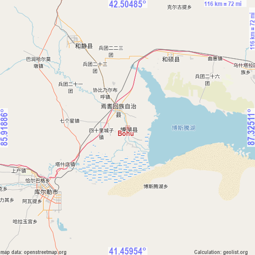
Bohu GPS coordinates[2]
41° 59' 3.624" North, 86° 37' 19.128" East
| Map corner | latitude | longitude |
|---|---|---|
| Upper-left | 42.50485°, | 85.91886° |
| Center: | 41.98434°, | 86.62198° |
| Lower-right: | 41.45954°, | 87.32511° |
| Map W x H: | 116.2×116.2 km | = 72.2×72.2mi |
| max Lat: | 53.31946° ⇑9% North |
| Bohu: | 41.98434° |
| min Lat: | ⇓91% South 18.22056° |
| min Long | Bohu | max Long |
| 75.07348° | 86.62198° | 134.28917° |
| W 1.8%⇐ | ⇒98.2% E |
Elevation
Elevation of Bohu is 1054 m = 3458 ft, and this is 569.2 m = 1867 ft above average elevation for this country.
| Max E: |
5622 m = 18445 ft | 13.8% |
| Bohu | 1054 m 3458 ft | |
| Avg. | 484.8 m = 1591 ft | |
Min E: |
-3 m = -10 ft | 86.2% |
See also: China elevation on elevation.city.
Geographical zone
Bohu is located in North temperate zone (between Tropic of Cancer and the Arctic Circle). Distance of this Northern Tropic circle is 2062.3 km =1281.5 mi to South.| Distance of | km | miles | from Bohu |
|---|---|---|---|
| North Pole | 5338.8 | 3317.4 | to North |
| Arctic Circle | 2733 | 1698.2 | to North |
| Tropic Cancer | 2062.3 | 1281.5 | to South |
| Equator | 4668.2 | 2900.7 | to South |


Nearby cities:
15 places around Bohu: (largest is in red/bold)
• Baluntaicun
79.9 km =49.6 mi,  342°
342°
• Dabancheng
206.4 km =128.3 mi,  42°
42°
• Ewirgol
138.3 km =85.9 mi, 38°
• Hejing
41.9 km =26 mi,  331°
331°
• Hoxut
36.2 km =22.5 mi,  32°
32°
• Huoche Xizhan
219.7 km =136.5 mi,  17°
17°
• Korla
46.2 km =28.7 mi,  237°
237°
• Luntai
198.2 km =123.2 mi,  263°
263°
• Sishilichengzi
12.3 km =7.6 mi, 258°
• Toksun
188.7 km =117.3 mi,  61°
61°
• Xingfulu
216.3 km =134.4 mi, 22°
• Yangzi Jianglu
213.9 km =132.9 mi, 21°
• Yanqi
9.8 km =6.1 mi, 331°
• Yuli
78.1 km =48.5 mi,  202°
202°
• Ürümqi
217.1 km =134.9 mi, 21°
Sources, notices
• [Note1] Compared only with cities in China existing in our database
• [Src1] Map data: © OpenStreetMap contributors (CC-BY-SA)
• [Src2] Other city data from geonames.org with taken over terms of usage.
• [Src3] Geographical zone / Annual Mean Temperature by Robert A. Rohde @ Wikipedia
