Unguía geodata
Unguía (Chocó) is a seat of a second-order administrative division; located in Colombia in America/Bogota (GMT-5) time zone. With population of 4,179 people, there are 563 cities with bigger population in this country. Compared to other cities in Colombia, 81% of cities are located further ↓South; 93.3% of cities are located further →East and 94.9% of cities have higher elevation than Unguía. Note1


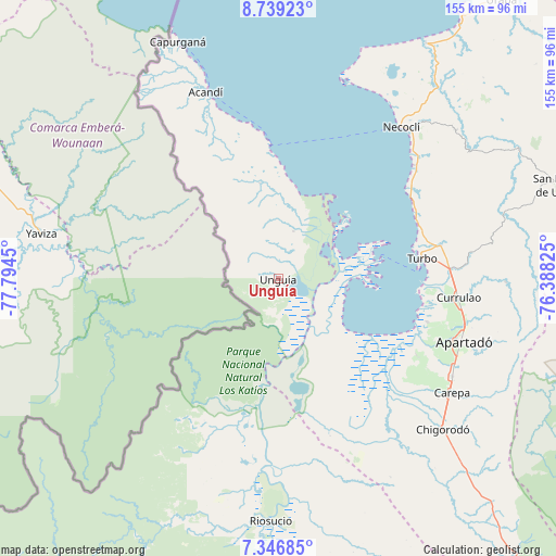
Unguía GPS coordinates[2]
8° 2' 37.104" North, 77° 5' 28.932" West
| Map corner | latitude | longitude |
|---|---|---|
| Upper-left | 8.73923°, | -77.7945° |
| Center: | 8.04364°, | -77.09137° |
| Lower-right: | 7.34685°, | -76.38825° |
| Map W x H: | 154.8×154.8 km | = 96.2×96.2mi |
| max Lat: | 13.38166° ⇑19% North |
| Unguía: | 8.04364° |
| min Lat: | ⇓81% South -4.21528° |
| min Long | Unguía | max Long |
| -81.70636° | -77.09137° | -67.06996° |
| W 6.7%⇐ | ⇒93.3% E |
Elevation
Elevation of Unguía is 14 m = 46 ft, and this is 1135.3 m = 3725 ft below average elevation for this country.
| Max E: |
3342 m = 10965 ft | 94.9% |
| Avg. | 1149.3 m = 3771 ft | |
| Unguía | 14 m = 46 ft | |
Min E: |
1 m = 3 ft | 5.1% |
See also: Colombia elevation on elevation.city.
Geographical zone
Unguía is located in North Torrid zone (between Equator and Tropic of Cancer). Distance of Equator is 894.4 km =555.8 mi to South.| Distance of | km | miles | from Unguía |
|---|---|---|---|
| North Pole | 9112.7 | 5662.4 | to North |
| Arctic Circle | 6506.8 | 4043.1 | to North |
| Tropic Cancer | 1711.6 | 1063.5 | to North |
| Equator | 894.4 | 555.8 | to South |


Nearby cities:
15 places around Unguía: (largest is in red/bold)
• Acandí
55.9 km =34.7 mi,  338°
338°
• Apartadó
54.3 km =33.7 mi,  109°
109°
• Arboletes
115.7 km =71.9 mi,  39°
39°
• Carepa
57.8 km =35.9 mi,  123°
123°
• Chigorodó
61.7 km =38.3 mi,  132°
132°
• Curbaradó
99.4 km =61.8 mi,  172°
172°
• Moñitos
116.9 km =72.6 mi,  78°
78°
• Mutatá
114.6 km =71.2 mi,  140°
140°
• Necoclí
54 km =33.6 mi, 38°
• Riosucio
66.8 km =41.5 mi,  182°
182°
• San Juan de Urabá
100.7 km =62.6 mi, 37°
• San Pedro de Urabá
82.8 km =51.4 mi,  71°
71°
• Tierralta
114.5 km =71.1 mi, 82°
• Turbo
40.3 km =25 mi, 82°
• Valencia
106.4 km =66.1 mi, 77°
Sources, notices
• [Note1] Compared only with cities in Colombia existing in our database
• [Src1] Map data: © OpenStreetMap contributors (CC-BY-SA)
• [Src2] Other city data from geonames.org with taken over terms of usage.
• [Src3] Geographical zone / Annual Mean Temperature by Robert A. Rohde @ Wikipedia
