Carepa geodata
Carepa (Antioquia) is a seat of a second-order administrative division; located in Colombia in America/Bogota (GMT-5) time zone. With population of 20,627 people, there are 172 cities with bigger population in this country. Compared to other cities in Colombia, 79.2% of cities are located further ↓South; 89.2% of cities are located further →East and 88% of cities have higher elevation than Carepa. Note1


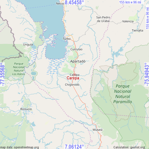
Carepa GPS coordinates[2]
7° 45' 30.564" North, 76° 39' 9.18" West
| Map corner | latitude | longitude |
|---|---|---|
| Upper-left | 8.45458°, | -77.35568° |
| Center: | 7.75849°, | -76.65255° |
| Lower-right: | 7.06124°, | -75.94943° |
| Map W x H: | 154.9×154.9 km | = 96.3×96.3mi |
| max Lat: | 13.38166° ⇑20.8% North |
| Carepa: | 7.75849° |
| min Lat: | ⇓79.2% South -4.21528° |
| min Long | Carepa | max Long |
| -81.70636° | -76.65255° | -67.06996° |
| W 10.8%⇐ | ⇒89.2% E |
Elevation
Elevation of Carepa is 38 m = 125 ft, and this is 1111.3 m = 3646 ft below average elevation for this country.
| Max E: |
3342 m = 10965 ft | 88% |
| Avg. | 1149.3 m = 3771 ft | |
| Carepa | 38 m = 125 ft | |
Min E: |
1 m = 3 ft | 12% |
See also: Colombia elevation on elevation.city.
Geographical zone
Carepa is located in North Torrid zone (between Equator and Tropic of Cancer). Distance of Equator is 862.7 km =536.1 mi to South.| Distance of | km | miles | from Carepa |
|---|---|---|---|
| North Pole | 9144.4 | 5682.1 | to North |
| Arctic Circle | 6538.5 | 4062.8 | to North |
| Tropic Cancer | 1743.3 | 1083.2 | to North |
| Equator | 862.7 | 536.1 | to South |


Nearby cities:
15 places around Carepa: (largest is in red/bold)
• Acandí
108.3 km =67.3 mi,  320°
320°
• Apartadó
14.2 km =8.8 mi,  11°
11°
• Chigorodó
10.7 km =6.6 mi,  197°
197°
• Curbaradó
75.5 km =46.9 mi,  207°
207°
• Dabeiba
94.3 km =58.6 mi,  153°
153°
• Moñitos
86 km =53.4 mi,  50°
50°
• Murindó
88.5 km =55 mi,  192°
192°
• Mutatá
62 km =38.5 mi,  157°
157°
• Necoclí
75.8 km =47.1 mi,  348°
348°
• Riosucio
62.3 km =38.7 mi,  235°
235°
• San Pedro de Urabá
65 km =40.4 mi,  27°
27°
• Tierralta
80 km =49.7 mi, 54°
• Turbo
38.1 km =23.7 mi, 347°
• Unguía
57.8 km =35.9 mi,  303°
303°
• Valencia
78.5 km =48.8 mi,  44°
44°
Sources, notices
• [Note1] Compared only with cities in Colombia existing in our database
• [Src1] Map data: © OpenStreetMap contributors (CC-BY-SA)
• [Src2] Other city data from geonames.org with taken over terms of usage.
• [Src3] Geographical zone / Annual Mean Temperature by Robert A. Rohde @ Wikipedia
