Chigorodó geodata
Chigorodó (Antioquia) is a seat of a second-order administrative division; located in Colombia in America/Bogota (GMT-5) time zone. With population of 48,443 people, there are 86 cities with bigger population in this country. Compared to other cities in Colombia, 79% of cities are located further ↓South; 89.4% of cities are located further →East and 88.9% of cities have higher elevation than Chigorodó. Note1


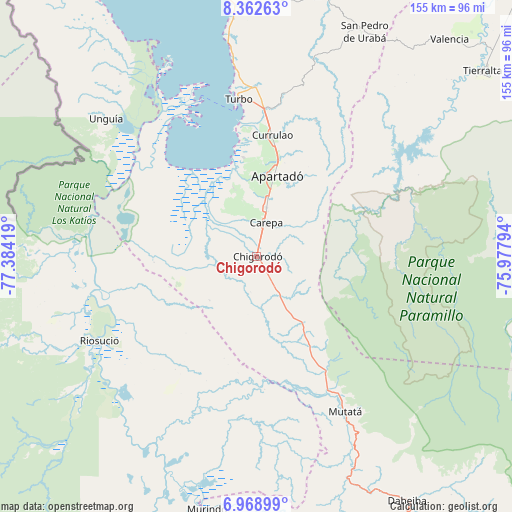
Chigorodó GPS coordinates[2]
7° 39' 58.968" North, 76° 40' 51.816" West
| Map corner | latitude | longitude |
|---|---|---|
| Upper-left | 8.36263°, | -77.38419° |
| Center: | 7.66638°, | -76.68106° |
| Lower-right: | 6.96899°, | -75.97794° |
| Map W x H: | 155×155 km | = 96.3×96.3mi |
| max Lat: | 13.38166° ⇑21% North |
| Chigorodó: | 7.66638° |
| min Lat: | ⇓79% South -4.21528° |
| min Long | Chigorodó | max Long |
| -81.70636° | -76.68106° | -67.06996° |
| W 10.6%⇐ | ⇒89.4% E |
Elevation
Elevation of Chigorodó is 35 m = 115 ft, and this is 1114.3 m = 3656 ft below average elevation for this country.
| Max E: |
3342 m = 10965 ft | 88.9% |
| Avg. | 1149.3 m = 3771 ft | |
| Chigorodó | 35 m = 115 ft | |
Min E: |
1 m = 3 ft | 11.1% |
See also: Chigorodó elevation on elevation.city.
Geographical zone
Chigorodó is located in North Torrid zone (between Equator and Tropic of Cancer). Distance of Equator is 852.4 km =529.7 mi to South.| Distance of | km | miles | from Chigorodó |
|---|---|---|---|
| North Pole | 9154.6 | 5688.4 | to North |
| Arctic Circle | 6548.8 | 4069.2 | to North |
| Tropic Cancer | 1753.5 | 1089.6 | to North |
| Equator | 852.4 | 529.7 | to South |


Nearby cities:
15 places around Chigorodó: (largest is in red/bold)
• Apartadó
24.8 km =15.4 mi,  14°
14°
• Carepa
10.7 km =6.6 mi,  17°
17°
• Curbaradó
65 km =40.4 mi,  209°
209°
• Dabeiba
86.9 km =54 mi,  148°
148°
• Moñitos
95.1 km =59.1 mi,  46°
46°
• Murindó
77.8 km =48.3 mi,  191°
191°
• Mutatá
54.2 km =33.7 mi, 150°
• Necoclí
85.3 km =53 mi,  351°
351°
• Riosucio
54.3 km =33.7 mi,  242°
242°
• San Pedro de Urabá
75.5 km =46.9 mi,  26°
26°
• Tierralta
88.7 km =55.1 mi, 50°
• Turbo
47.7 km =29.6 mi, 353°
• Unguía
61.7 km =38.3 mi,  312°
312°
• Uramita
102 km =63.4 mi, 146°
• Valencia
88.1 km =54.7 mi,  41°
41°
Sources, notices
• [Note1] Compared only with cities in Colombia existing in our database
• [Src1] Map data: © OpenStreetMap contributors (CC-BY-SA)
• [Src2] Other city data from geonames.org with taken over terms of usage.
• [Src3] Geographical zone / Annual Mean Temperature by Robert A. Rohde @ Wikipedia
