Purificación geodata
Purificación (Tolima) is a seat of a second-order administrative division; located in Colombia in America/Bogota (GMT-5) time zone. With population of 10,846 people, there are 285 cities with bigger population in this country. Compared to other cities in Colombia, 79.3% of cities are located further ↑North; 52.6% of cities are located further →East and 69.5% of cities have higher elevation than Purificación. Note1


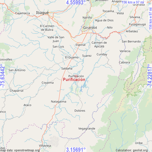
Purificación GPS coordinates[2]
3° 51' 31.356" North, 74° 55' 52.644" West
| Map corner | latitude | longitude |
|---|---|---|
| Upper-left | 4.55993°, | -75.63442° |
| Center: | 3.85871°, | -74.93129° |
| Lower-right: | 3.15691°, | -74.22817° |
| Map W x H: | 156×156 km | = 96.9×96.9mi |
| max Lat: | 13.38166° ⇑79.3% North |
| Purificación: | 3.85871° |
| min Lat: | ⇓20.7% South -4.21528° |
| min Long | Purificación | max Long |
| -81.70636° | -74.93129° | -67.06996° |
| W 47.4%⇐ | ⇒52.6% E |
Elevation
Elevation of Purificación is 305 m = 1001 ft, and this is 844.3 m = 2770 ft below average elevation for this country.
| Max E: |
3342 m = 10965 ft | 69.5% |
| Avg. | 1149.3 m = 3771 ft | |
| Purificación | 305 m = 1001 ft | |
Min E: |
1 m = 3 ft | 30.5% |
See also: Colombia elevation on elevation.city.
Geographical zone
Purificación is located in North Torrid zone (between Equator and Tropic of Cancer). Distance of Equator is 429 km =266.6 mi to South.| Distance of | km | miles | from Purificación |
|---|---|---|---|
| North Pole | 9578 | 5951.5 | to North |
| Arctic Circle | 6972.1 | 4332.3 | to North |
| Tropic Cancer | 2176.9 | 1352.7 | to North |
| Equator | 429 | 266.6 | to South |


Nearby cities:
15 places around Purificación: (largest is in red/bold)
• Carmen de Apicalá
39.7 km =24.7 mi,  36°
36°
• Coyaima
30 km =18.6 mi,  257°
257°
• Cunday
34.7 km =21.6 mi,  49°
49°
• Dolores
35.7 km =22.2 mi,  173°
173°
• Espinal
32.7 km =20.3 mi,  9°
9°
• Guamo
19.6 km =12.2 mi,  347°
347°
• La Chamba
19.9 km =12.4 mi,  20°
20°
• Natagaima
32.1 km =19.9 mi,  214°
214°
• Ortega
33.3 km =20.7 mi,  284°
284°
• Prado
12 km =7.5 mi,  179°
179°
• Saldaña
12.2 km =7.6 mi,  310°
310°
• San Luis
35.5 km =22.1 mi,  329°
329°
• Suárez
23.9 km =14.9 mi,  27°
27°
• Tres Esquinas
24.7 km =15.3 mi,  88°
88°
• Villarrica
37.7 km =23.4 mi,  76°
76°
Sources, notices
• [Note1] Compared only with cities in Colombia existing in our database
• [Src1] Map data: © OpenStreetMap contributors (CC-BY-SA)
• [Src2] Other city data from geonames.org with taken over terms of usage.
• [Src3] Geographical zone / Annual Mean Temperature by Robert A. Rohde @ Wikipedia
