Guamo geodata
Guamo (Tolima) is a seat of a second-order administrative division; located in Colombia in America/Bogota (GMT-5) time zone. With population of 14,881 people, there are 223 cities with bigger population in this country. Compared to other cities in Colombia, 77.8% of cities are located further ↑North; 53.3% of cities are located further →East and 68.6% of cities have higher elevation than Guamo. Note1


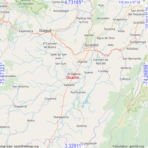
Guamo GPS coordinates[2]
4° 1' 50.808" North, 74° 58' 12.36" West
| Map corner | latitude | longitude |
|---|---|---|
| Upper-left | 4.73185°, | -75.67323° |
| Center: | 4.03078°, | -74.9701° |
| Lower-right: | 3.32911°, | -74.26698° |
| Map W x H: | 156×156 km | = 96.9×96.9mi |
| max Lat: | 13.38166° ⇑77.8% North |
| Guamo: | 4.03078° |
| min Lat: | ⇓22.2% South -4.21528° |
| min Long | Guamo | max Long |
| -81.70636° | -74.9701° | -67.06996° |
| W 46.7%⇐ | ⇒53.3% E |
Elevation
Elevation of Guamo is 323 m = 1060 ft, and this is 826.3 m = 2711 ft below average elevation for this country.
| Max E: |
3342 m = 10965 ft | 68.6% |
| Avg. | 1149.3 m = 3771 ft | |
| Guamo | 323 m = 1060 ft | |
Min E: |
1 m = 3 ft | 31.4% |
See also: Colombia elevation on elevation.city.
Geographical zone
Guamo is located in North Torrid zone (between Equator and Tropic of Cancer). Distance of Equator is 448.2 km =278.5 mi to South.| Distance of | km | miles | from Guamo |
|---|---|---|---|
| North Pole | 9558.9 | 5939.6 | to North |
| Arctic Circle | 6953 | 4320.4 | to North |
| Tropic Cancer | 2157.7 | 1340.7 | to North |
| Equator | 448.2 | 278.5 | to South |


Nearby cities:
15 places around Guamo: (largest is in red/bold)
• Carmen de Apicalá
30.6 km =19 mi,  64°
64°
• Chicoral
20.6 km =12.8 mi,  356°
356°
• Coello
29.8 km =18.5 mi,  15°
15°
• Cunday
31 km =19.3 mi,  83°
83°
• Espinal
16.2 km =10.1 mi,  35°
35°
• Flandes
33.5 km =20.8 mi,  30°
30°
• La Chamba
11.3 km =7 mi,  92°
92°
• Ortega
29.8 km =18.5 mi,  249°
249°
• Payandé
32.8 km =20.4 mi,  334°
334°
• Prado
31.4 km =19.5 mi,  171°
171°
• Purificación
19.6 km =12.2 mi, 167°
• Saldaña
12.3 km =7.6 mi,  203°
203°
• San Luis
17.9 km =11.1 mi,  309°
309°
• Suárez
15.5 km =9.6 mi, 82°
• Valle de San Juan
24.8 km =15.4 mi,  318°
318°
Sources, notices
• [Note1] Compared only with cities in Colombia existing in our database
• [Src1] Map data: © OpenStreetMap contributors (CC-BY-SA)
• [Src2] Other city data from geonames.org with taken over terms of usage.
• [Src3] Geographical zone / Annual Mean Temperature by Robert A. Rohde @ Wikipedia
