Guayabetal geodata
Guayabetal (Cundinamarca) is a seat of a second-order administrative division; located in Colombia in America/Bogota (GMT-5) time zone. With population of 2,017 people, there are 797 cities with bigger population in this country. Compared to other cities in Colombia, 76% of cities are located further ↑North; 69.2% of cities are located further ←West and 51.1% of cities have higher elevation than Guayabetal. Note1


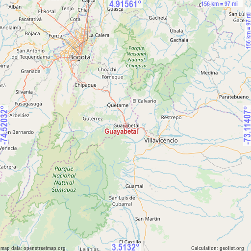
Guayabetal GPS coordinates[2]
4° 12' 52.992" North, 73° 49' 1.884" West
| Map corner | latitude | longitude |
|---|---|---|
| Upper-left | 4.91561°, | -74.52032° |
| Center: | 4.21472°, | -73.81719° |
| Lower-right: | 3.5132°, | -73.11407° |
| Map W x H: | 155.9×155.9 km | = 96.9×96.9mi |
| max Lat: | 13.38166° ⇑76% North |
| Guayabetal: | 4.21472° |
| min Lat: | ⇓24% South -4.21528° |
| min Long | Guayabetal | max Long |
| -81.70636° | -73.81719° | -67.06996° |
| W 69.2%⇐ | ⇒30.8% E |
Elevation
Elevation of Guayabetal is 1087 m = 3566 ft, and this is 62.3 m = 204 ft below average elevation for this country.
| Max E: |
3342 m = 10965 ft | 51.1% |
| Avg. | 1149.3 m = 3771 ft | |
| Guayabetal | 1087 m = 3566 ft | |
Min E: |
1 m = 3 ft | 48.9% |
See also: Colombia elevation on elevation.city.
Geographical zone
Guayabetal is located in North Torrid zone (between Equator and Tropic of Cancer). Distance of Equator is 468.6 km =291.2 mi to South.| Distance of | km | miles | from Guayabetal |
|---|---|---|---|
| North Pole | 9538.4 | 5926.9 | to North |
| Arctic Circle | 6932.5 | 4307.7 | to North |
| Tropic Cancer | 2137.3 | 1328.1 | to North |
| Equator | 468.6 | 291.2 | to South |


Nearby cities:
15 places around Guayabetal: (largest is in red/bold)
• Acacías
26.2 km =16.3 mi,  165°
165°
• Chipaque
35.7 km =22.2 mi,  315°
315°
• Choachí
36.8 km =22.9 mi,  341°
341°
• Cumaral
37.2 km =23.1 mi,  80°
80°
• Cáqueza
25.6 km =15.9 mi,  325°
325°
• El Calvario
19.4 km =12.1 mi,  37°
37°
• Fosca
19.3 km =12 mi, 315°
• Fómeque
31.7 km =19.7 mi, 343°
• Gutiérrez
21 km =13 mi,  282°
282°
• Quetame
14 km =8.7 mi, 339°
• Restrepo
28.8 km =17.9 mi, 80°
• San Juanito
31.3 km =19.4 mi,  28°
28°
• Ubaque
33 km =20.5 mi, 336°
• Une
31.2 km =19.4 mi,  312°
312°
• Villavicencio
22.6 km =14 mi,  110°
110°
Sources, notices
• [Note1] Compared only with cities in Colombia existing in our database
• [Src1] Map data: © OpenStreetMap contributors (CC-BY-SA)
• [Src2] Other city data from geonames.org with taken over terms of usage.
• [Src3] Geographical zone / Annual Mean Temperature by Robert A. Rohde @ Wikipedia
