Quetame geodata
Quetame (Cundinamarca) is a seat of a second-order administrative division; located in Colombia in America/Bogota (GMT-5) time zone. With population of 1,374 people, there are 891 cities with bigger population in this country. Compared to other cities in Colombia, 74.3% of cities are located further ↑North; 68.3% of cities are located further ←West and 64.8% of cities have lower elevation than Quetame. Note1


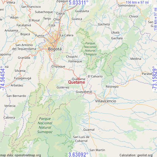
Quetame GPS coordinates[2]
4° 19' 56.424" North, 73° 51' 41.076" West
| Map corner | latitude | longitude |
|---|---|---|
| Upper-left | 5.03311°, | -74.56454° |
| Center: | 4.33234°, | -73.86141° |
| Lower-right: | 3.63092°, | -73.15829° |
| Map W x H: | 155.9×155.9 km | = 96.9×96.9mi |
| max Lat: | 13.38166° ⇑74.3% North |
| Quetame: | 4.33234° |
| min Lat: | ⇓25.7% South -4.21528° |
| min Long | Quetame | max Long |
| -81.70636° | -73.86141° | -67.06996° |
| W 68.3%⇐ | ⇒31.7% E |
Elevation
Elevation of Quetame is 1585 m = 5200 ft, and this is 435.7 m = 1429 ft above average elevation for this country.
| Max E: |
3342 m = 10965 ft | 35.2% |
| Quetame | 1585 m 5200 ft | |
| Avg. | 1149.3 m = 3771 ft | |
Min E: |
1 m = 3 ft | 64.8% |
See also: Colombia elevation on elevation.city.
Geographical zone
Quetame is located in North Torrid zone (between Equator and Tropic of Cancer). Distance of Equator is 481.7 km =299.3 mi to South.| Distance of | km | miles | from Quetame |
|---|---|---|---|
| North Pole | 9525.4 | 5918.8 | to North |
| Arctic Circle | 6919.5 | 4299.6 | to North |
| Tropic Cancer | 2124.2 | 1319.9 | to North |
| Equator | 481.7 | 299.3 | to South |


Nearby cities:
15 places around Quetame: (largest is in red/bold)
• Acacías
40.1 km =24.9 mi,  163°
163°
• Bogotá
39.3 km =24.4 mi,  321°
321°
• Chipaque
23.7 km =14.7 mi,  301°
301°
• Choachí
22.9 km =14.2 mi,  342°
342°
• Cáqueza
12.5 km =7.8 mi,  310°
310°
• El Calvario
16.8 km =10.4 mi,  81°
81°
• Fosca
8.6 km =5.3 mi,  275°
275°
• Fómeque
17.8 km =11.1 mi,  346°
346°
• Guayabetal
14 km =8.7 mi, 159°
• Gutiérrez
17.9 km =11.1 mi,  241°
241°
• Restrepo
34.3 km =21.3 mi,  103°
103°
• San Juanito
24.6 km =15.3 mi,  54°
54°
• Ubaque
19.1 km =11.9 mi,  333°
333°
• Une
19.8 km =12.3 mi,  293°
293°
• Villavicencio
33.6 km =20.9 mi,  129°
129°
Sources, notices
• [Note1] Compared only with cities in Colombia existing in our database
• [Src1] Map data: © OpenStreetMap contributors (CC-BY-SA)
• [Src2] Other city data from geonames.org with taken over terms of usage.
• [Src3] Geographical zone / Annual Mean Temperature by Robert A. Rohde @ Wikipedia
