Fosca geodata
Fosca (Cundinamarca) is a seat of a second-order administrative division; located in Colombia in America/Bogota (GMT-5) time zone. With population of 1,451 people, there are 874 cities with bigger population in this country. Compared to other cities in Colombia, 73.8% of cities are located further ↑North; 66.5% of cities are located further ←West and 81.4% of cities have lower elevation than Fosca. Note1


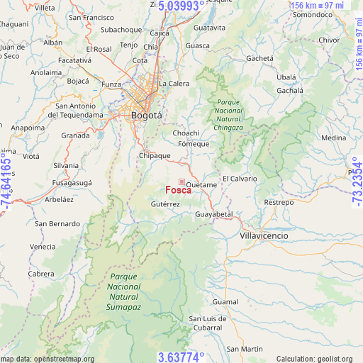
Fosca GPS coordinates[2]
4° 20' 20.976" North, 73° 56' 18.672" West
| Map corner | latitude | longitude |
|---|---|---|
| Upper-left | 5.03993°, | -74.64165° |
| Center: | 4.33916°, | -73.93852° |
| Lower-right: | 3.63774°, | -73.2354° |
| Map W x H: | 155.9×155.9 km | = 96.9×96.9mi |
| max Lat: | 13.38166° ⇑73.8% North |
| Fosca: | 4.33916° |
| min Lat: | ⇓26.2% South -4.21528° |
| min Long | Fosca | max Long |
| -81.70636° | -73.93852° | -67.06996° |
| W 66.5%⇐ | ⇒33.5% E |
Elevation
Elevation of Fosca is 2112 m = 6929 ft, and this is 962.7 m = 3158 ft above average elevation for this country.
| Max E: |
3342 m = 10965 ft | 18.6% |
| Fosca | 2112 m 6929 ft | |
| Avg. | 1149.3 m = 3771 ft | |
Min E: |
1 m = 3 ft | 81.4% |
See also: Colombia elevation on elevation.city.
Geographical zone
Fosca is located in North Torrid zone (between Equator and Tropic of Cancer). Distance of Equator is 482.5 km =299.8 mi to South.| Distance of | km | miles | from Fosca |
|---|---|---|---|
| North Pole | 9524.6 | 5918.3 | to North |
| Arctic Circle | 6918.7 | 4299.1 | to North |
| Tropic Cancer | 2123.4 | 1319.4 | to North |
| Equator | 482.5 | 299.8 | to South |


Nearby cities:
15 places around Fosca: (largest is in red/bold)
• Barrio San Luis
37.7 km =23.4 mi,  345°
345°
• Bogotá
34 km =21.1 mi,  332°
332°
• Chipaque
16.4 km =10.2 mi,  314°
314°
• Choachí
21.2 km =13.2 mi,  4°
4°
• Cáqueza
7.5 km =4.7 mi, 352°
• El Calvario
25.2 km =15.7 mi,  86°
86°
• Fómeque
17.2 km =10.7 mi,  15°
15°
• Guayabetal
19.3 km =12 mi,  135°
135°
• Gutiérrez
11.8 km =7.3 mi,  217°
217°
• Pasca
40.3 km =25 mi,  264°
264°
• Quetame
8.6 km =5.3 mi,  95°
95°
• San Juanito
31.7 km =19.7 mi,  64°
64°
• Sibaté
39.4 km =24.5 mi,  295°
295°
• Ubaque
16.4 km =10.2 mi, 0°
• Une
12 km =7.5 mi, 306°
Sources, notices
• [Note1] Compared only with cities in Colombia existing in our database
• [Src1] Map data: © OpenStreetMap contributors (CC-BY-SA)
• [Src2] Other city data from geonames.org with taken over terms of usage.
• [Src3] Geographical zone / Annual Mean Temperature by Robert A. Rohde @ Wikipedia
