San Luis geodata
San Luis (Tolima) is a seat of a second-order administrative division; located in Colombia in America/Bogota (GMT-5) time zone. With population of 4,184 people, there are 561 cities with bigger population in this country. Compared to other cities in Colombia, 77.2% of cities are located further ↑North; 56.2% of cities are located further →East and 64.2% of cities have higher elevation than San Luis. Note1


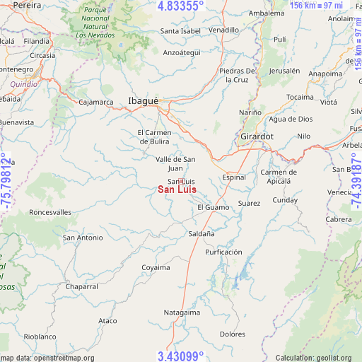
San Luis GPS coordinates[2]
4° 7' 57.288" North, 75° 5' 41.964" West
| Map corner | latitude | longitude |
|---|---|---|
| Upper-left | 4.83355°, | -75.79812° |
| Center: | 4.13258°, | -75.09499° |
| Lower-right: | 3.43099°, | -74.39187° |
| Map W x H: | 156×156 km | = 96.9×96.9mi |
| max Lat: | 13.38166° ⇑77.2% North |
| San Luis: | 4.13258° |
| min Lat: | ⇓22.8% South -4.21528° |
| min Long | San Luis | max Long |
| -81.70636° | -75.09499° | -67.06996° |
| W 43.8%⇐ | ⇒56.2% E |
Elevation
Elevation of San Luis is 478 m = 1568 ft, and this is 671.3 m = 2202 ft below average elevation for this country.
| Max E: |
3342 m = 10965 ft | 64.2% |
| Avg. | 1149.3 m = 3771 ft | |
| San Luis | 478 m = 1568 ft | |
Min E: |
1 m = 3 ft | 35.8% |
See also: Colombia elevation on elevation.city.
Geographical zone
San Luis is located in North Torrid zone (between Equator and Tropic of Cancer). Distance of Equator is 459.5 km =285.5 mi to South.| Distance of | km | miles | from San Luis |
|---|---|---|---|
| North Pole | 9547.6 | 5932.6 | to North |
| Arctic Circle | 6941.7 | 4313.4 | to North |
| Tropic Cancer | 2146.4 | 1333.7 | to North |
| Equator | 459.5 | 285.5 | to South |


Nearby cities:
15 places around San Luis: (largest is in red/bold)
• Chicoral
15.6 km =9.7 mi,  53°
53°
• Coello
27.9 km =17.3 mi, 51°
• Doima
35.3 km =21.9 mi,  22°
22°
• Espinal
23.4 km =14.5 mi,  85°
85°
• Flandes
35.5 km =22.1 mi,  60°
60°
• Guamo
17.9 km =11.1 mi,  129°
129°
• La Chamba
27.8 km =17.3 mi,  115°
115°
• Laureles
28.9 km =18 mi,  299°
299°
• Ortega
26 km =16.2 mi,  212°
212°
• Payandé
18.3 km =11.4 mi,  359°
359°
• Purificación
35.5 km =22.1 mi,  149°
149°
• Rovira
20 km =12.4 mi,  306°
306°
• Saldaña
24.3 km =15.1 mi,  158°
158°
• Suárez
30.6 km =19 mi,  107°
107°
• Valle de San Juan
7.8 km =4.8 mi,  341°
341°
Sources, notices
• [Note1] Compared only with cities in Colombia existing in our database
• [Src1] Map data: © OpenStreetMap contributors (CC-BY-SA)
• [Src2] Other city data from geonames.org with taken over terms of usage.
• [Src3] Geographical zone / Annual Mean Temperature by Robert A. Rohde @ Wikipedia
