San José geodata
San José (Alajuela) is a populated place; located in Costa Rica in America/Costa_Rica (GMT-6) time zone. With population of 31,430 people, there are 11 cities with bigger population in this country. Compared to other cities in Costa Rica, 98.5% of cities are located further ↓South; 90.3% of cities are located further →East and 85.8% of cities have higher elevation than San José. Note1


San José GPS coordinates[2]
10° 57' 6.228" North, 85° 8' 9.96" West
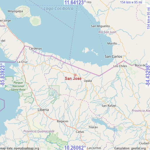
| Map corner | latitude | longitude |
|---|---|---|
| Upper-left | 11.64123°, | -85.83923° |
| Center: | 10.95173°, | -85.1361° |
| Lower-right: | 10.26062°, | -84.43298° |
| Map W x H: | 153.5×153.5 km | = 95.4×95.4mi |
| max Lat: | 11.07377° ⇑1.5% North |
| San José: | 10.95173° |
| min Lat: | ⇓98.5% South 8.53305° |
| min Long | San José | max Long |
| -85.64748° | -85.1361° | -82.62185° |
| W 9.7%⇐ | ⇒90.3% E |
Elevation
Elevation of San José is 50 m = 164 ft, and this is 685 m = 2247 ft below average elevation for this country.
| Max E: |
1844 m = 6050 ft | 85.8% |
| Avg. | 735 m = 2411 ft | |
| San José | 50 m = 164 ft | |
Min E: |
7 m = 23 ft | 14.2% |
See also: Costa Rica elevation on elevation.city.
Geographical zone
San José is located in North Torrid zone (between Equator and Tropic of Cancer). Distance of Equator is 1217.7 km =756.6 mi to South.| Distance of | km | miles | from San José |
|---|---|---|---|
| North Pole | 8789.3 | 5461.4 | to North |
| Arctic Circle | 6183.5 | 3842.2 | to North |
| Tropic Cancer | 1388.2 | 862.6 | to North |
| Equator | 1217.7 | 756.6 | to South |


Nearby cities:
15 places around San José: (largest is in red/bold)
• Bagaces
49.2 km =30.6 mi,  195°
195°
• Belén
78.1 km =48.5 mi,  219°
219°
• Bijagua
25.8 km =16 mi,  160°
160°
• Cañas
58 km =36 mi,  175°
175°
• Fortuna
31.7 km =19.7 mi,  192°
192°
• Juntas
77 km =47.8 mi,  165°
165°
• La Cruz
55.9 km =34.7 mi,  284°
284°
• La Fortuna
75.7 km =47 mi,  134°
134°
• Liberia
48.2 km =30 mi, 223°
• Los Chiles
46.7 km =29 mi,  78°
78°
• Pocosol
86.3 km =53.6 mi,  138°
138°
• Santa Cruz
91.2 km =56.7 mi,  212°
212°
• Sardinal
73.9 km =45.9 mi,  229°
229°
• Tilarán
56.9 km =35.4 mi, 161°
• Upala
14.6 km =9.1 mi,  114°
114°
Sources, notices
• [Note1] Compared only with cities in Costa Rica existing in our database
• [Src1] Map data: © OpenStreetMap contributors (CC-BY-SA)
• [Src2] Other city data from geonames.org with taken over terms of usage.
• [Src3] Geographical zone / Annual Mean Temperature by Robert A. Rohde @ Wikipedia
