San Vito geodata
San Vito (Puntarenas) is a populated place; located in Costa Rica in America/Costa_Rica (GMT-6) time zone. With population of 3,981 people, there are 87 cities with bigger population in this country. Compared to other cities in Costa Rica, 97% of cities are located further ↑North; 96.3% of cities are located further ←West and 56.7% of cities have lower elevation than San Vito. Note1


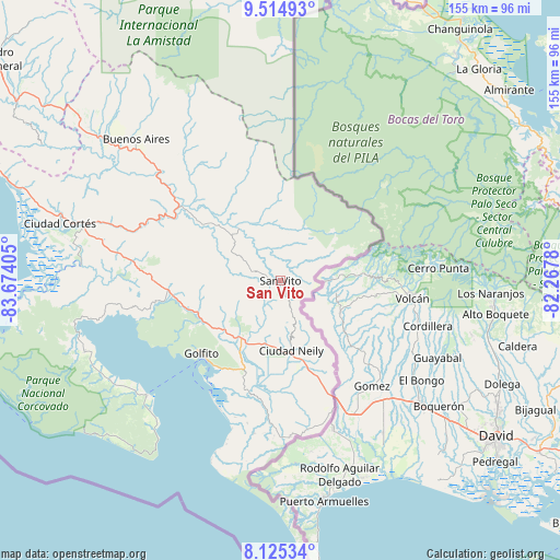
San Vito GPS coordinates[2]
8° 49' 14.844" North, 82° 58' 15.312" West
| Map corner | latitude | longitude |
|---|---|---|
| Upper-left | 9.51493°, | -83.67405° |
| Center: | 8.82079°, | -82.97092° |
| Lower-right: | 8.12534°, | -82.2678° |
| Map W x H: | 154.5×154.5 km | = 96×96mi |
| max Lat: | 11.07377° ⇑97% North |
| San Vito: | 8.82079° |
| min Lat: | ⇓3% South 8.53305° |
| min Long | San Vito | max Long |
| -85.64748° | -82.97092° | -82.62185° |
| W 96.3%⇐ | ⇒3.7% E |
Elevation
Elevation of San Vito is 994 m = 3261 ft, and this is 259 m = 850 ft above average elevation for this country.
| Max E: |
1844 m = 6050 ft | 43.3% |
| San Vito | 994 m 3261 ft | |
| Avg. | 735 m = 2411 ft | |
Min E: |
7 m = 23 ft | 56.7% |
See also: Costa Rica elevation on elevation.city.
Geographical zone
San Vito is located in North Torrid zone (between Equator and Tropic of Cancer). Distance of Equator is 980.8 km =609.4 mi to South.| Distance of | km | miles | from San Vito |
|---|---|---|---|
| North Pole | 9026.3 | 5608.7 | to North |
| Arctic Circle | 6420.4 | 3989.5 | to North |
| Tropic Cancer | 1625.1 | 1009.8 | to North |
| Equator | 980.8 | 609.4 | to South |


Nearby cities:
15 places around San Vito: (largest is in red/bold)
• Buenos Aires
55.8 km =34.7 mi,  314°
314°
• Cahuita
103 km =64 mi,  7°
7°
• Canoas
35.2 km =21.9 mi,  155°
155°
• Ciudad Cortés
62.7 km =39 mi,  284°
284°
• Corredor
20.3 km =12.6 mi,  172°
172°
• Daniel Flores
95.7 km =59.5 mi, 306°
• Golfito
28.8 km =17.9 mi,  212°
212°
• La Suiza
134.7 km =83.7 mi,  328°
328°
• Limón
130.3 km =81 mi,  356°
356°
• Mercedes
83.2 km =51.7 mi, 306°
• Pejibaye
136.3 km =84.7 mi,  323°
323°
• Sabalito
6.8 km =4.2 mi,  92°
92°
• San Isidro
100.3 km =62.3 mi, 307°
• Sixaola
87.4 km =54.3 mi,  25°
25°
• Tucurrique
141.4 km =87.9 mi, 324°
Sources, notices
• [Note1] Compared only with cities in Costa Rica existing in our database
• [Src1] Map data: © OpenStreetMap contributors (CC-BY-SA)
• [Src2] Other city data from geonames.org with taken over terms of usage.
• [Src3] Geographical zone / Annual Mean Temperature by Robert A. Rohde @ Wikipedia
