Golfito geodata
Golfito (Puntarenas) is a seat of a second-order administrative division; located in Costa Rica in America/Costa_Rica (GMT-6) time zone. With population of 6,777 people, there are 67 cities with bigger population in this country. Compared to other cities in Costa Rica, 99.3% of cities are located further ↑North; 94.8% of cities are located further ←West and 88.1% of cities have higher elevation than Golfito. Note1


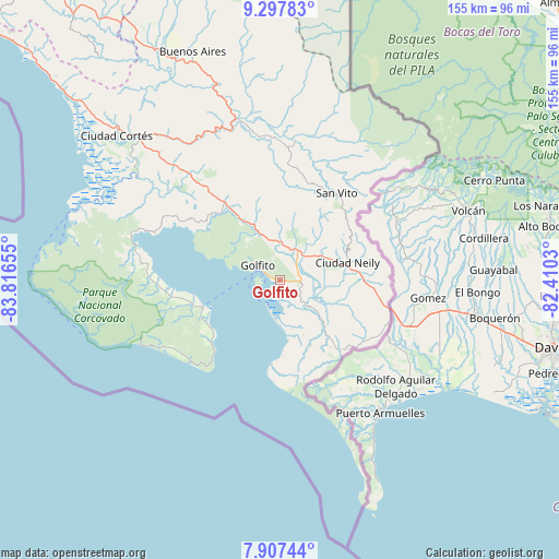
Golfito GPS coordinates[2]
8° 36' 11.772" North, 83° 6' 48.312" West
| Map corner | latitude | longitude |
|---|---|---|
| Upper-left | 9.29783°, | -83.81655° |
| Center: | 8.60327°, | -83.11342° |
| Lower-right: | 7.90744°, | -82.4103° |
| Map W x H: | 154.6×154.6 km | = 96.1×96.1mi |
| max Lat: | 11.07377° ⇑99.3% North |
| Golfito: | 8.60327° |
| min Lat: | ⇓0.7% South 8.53305° |
| min Long | Golfito | max Long |
| -85.64748° | -83.11342° | -82.62185° |
| W 94.8%⇐ | ⇒5.2% E |
Elevation
Elevation of Golfito is 39 m = 128 ft, and this is 696 m = 2283 ft below average elevation for this country.
| Max E: |
1844 m = 6050 ft | 88.1% |
| Avg. | 735 m = 2411 ft | |
| Golfito | 39 m = 128 ft | |
Min E: |
7 m = 23 ft | 11.9% |
See also: Costa Rica elevation on elevation.city.
Geographical zone
Golfito is located in North Torrid zone (between Equator and Tropic of Cancer). Distance of Equator is 956.6 km =594.4 mi to South.| Distance of | km | miles | from Golfito |
|---|---|---|---|
| North Pole | 9050.5 | 5623.7 | to North |
| Arctic Circle | 6444.6 | 4004.5 | to North |
| Tropic Cancer | 1649.3 | 1024.8 | to North |
| Equator | 956.6 | 594.4 | to South |


Nearby cities:
15 places around Golfito: (largest is in red/bold)
• Buenos Aires
67.7 km =42.1 mi,  339°
339°
• Cahuita
129.7 km =80.6 mi,  13°
13°
• Canoas
31.2 km =19.4 mi,  104°
104°
• Ciudad Cortés
60 km =37.3 mi,  311°
311°
• Corredor
18.9 km =11.7 mi,  77°
77°
• Daniel Flores
101.8 km =63.3 mi,  323°
323°
• La Suiza
149.3 km =92.8 mi, 338°
• Mercedes
89.6 km =55.7 mi, 324°
• Pejibaye
149.1 km =92.6 mi,  334°
334°
• Quepos
147.4 km =91.6 mi, 308°
• Sabalito
32.8 km =20.4 mi,  43°
43°
• San Isidro
106.4 km =66.1 mi, 322°
• San Marcos
154 km =95.7 mi, 319°
• San Vito
28.8 km =17.9 mi,  32°
32°
• Sixaola
116.1 km =72.1 mi, 27°
Sources, notices
• [Note1] Compared only with cities in Costa Rica existing in our database
• [Src1] Map data: © OpenStreetMap contributors (CC-BY-SA)
• [Src2] Other city data from geonames.org with taken over terms of usage.
• [Src3] Geographical zone / Annual Mean Temperature by Robert A. Rohde @ Wikipedia
