Canoas geodata
Canoas (Puntarenas) is a populated place; located in Costa Rica in America/Costa_Rica (GMT-6) time zone. With population of 4,573 people, there are 77 cities with bigger population in this country. Compared to other cities in Costa Rica, 100% of cities are located further ↑North; 99.3% of cities are located further ←West and 76.9% of cities have higher elevation than Canoas. Note1


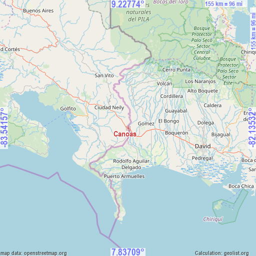
Canoas GPS coordinates[2]
8° 31' 58.98" North, 82° 50' 18.384" West
| Map corner | latitude | longitude |
|---|---|---|
| Upper-left | 9.22774°, | -83.54157° |
| Center: | 8.53305°, | -82.83844° |
| Lower-right: | 7.83709°, | -82.13532° |
| Map W x H: | 154.6×154.6 km | = 96.1×96.1mi |
| max Lat: | 11.07377° ⇑100% North |
| Canoas: | 8.53305° |
| min Lat: | ⇓0% South 8.53305° |
| min Long | Canoas | max Long |
| -85.64748° | -82.83844° | -82.62185° |
| W 99.3%⇐ | ⇒0.7% E |
Elevation
Elevation of Canoas is 128 m = 420 ft, and this is 607 m = 1991 ft below average elevation for this country.
| Max E: |
1844 m = 6050 ft | 76.9% |
| Avg. | 735 m = 2411 ft | |
| Canoas | 128 m = 420 ft | |
Min E: |
7 m = 23 ft | 23.1% |
See also: Costa Rica elevation on elevation.city.
Geographical zone
Canoas is located in North Torrid zone (between Equator and Tropic of Cancer). Distance of Equator is 948.8 km =589.6 mi to South.| Distance of | km | miles | from Canoas |
|---|---|---|---|
| North Pole | 9058.3 | 5628.6 | to North |
| Arctic Circle | 6452.4 | 4009.3 | to North |
| Tropic Cancer | 1657.1 | 1029.7 | to North |
| Equator | 948.8 | 589.6 | to South |


Nearby cities:
15 places around Canoas: (largest is in red/bold)
• Buenos Aires
89.5 km =55.6 mi,  322°
322°
• Cahuita
134 km =83.3 mi,  359°
359°
• Ciudad Cortés
89 km =55.3 mi,  302°
302°
• Corredor
16.8 km =10.4 mi, 315°
• Daniel Flores
127.6 km =79.3 mi,  314°
314°
• Golfito
31.2 km =19.4 mi,  284°
284°
• La Suiza
169.6 km =105.4 mi,  329°
329°
• Limón
163.5 km =101.6 mi,  352°
352°
• Mercedes
115.1 km =71.5 mi, 314°
• Pejibaye
170.9 km =106.2 mi, 326°
• Sabalito
32.6 km =20.3 mi, 346°
• San Isidro
132.3 km =82.2 mi, 314°
• San Vito
35.2 km =21.9 mi,  335°
335°
• Sixaola
113.1 km =70.3 mi,  12°
12°
• Tucurrique
176 km =109.4 mi, 326°
Sources, notices
• [Note1] Compared only with cities in Costa Rica existing in our database
• [Src1] Map data: © OpenStreetMap contributors (CC-BY-SA)
• [Src2] Other city data from geonames.org with taken over terms of usage.
• [Src3] Geographical zone / Annual Mean Temperature by Robert A. Rohde @ Wikipedia
