Corredor geodata
Corredor (Puntarenas) is a populated place; located in Costa Rica in America/Costa_Rica (GMT-6) time zone. With population of 7,084 people, there are 63 cities with bigger population in this country. Compared to other cities in Costa Rica, 98.5% of cities are located further ↑North; 97% of cities are located further ←West and 88.8% of cities have higher elevation than Corredor. Note1


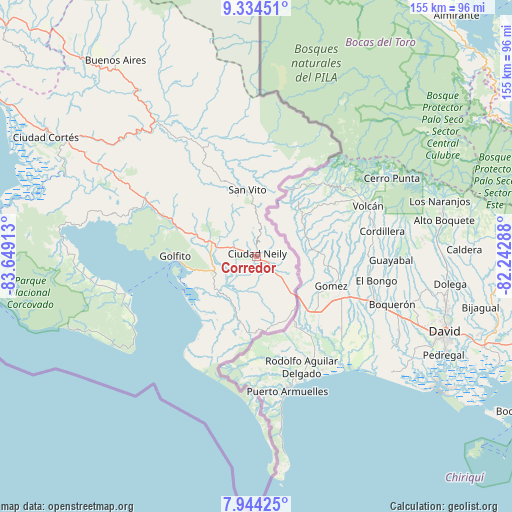
Corredor GPS coordinates[2]
8° 38' 24.072" North, 82° 56' 45.6" West
| Map corner | latitude | longitude |
|---|---|---|
| Upper-left | 9.33451°, | -83.64913° |
| Center: | 8.64002°, | -82.946° |
| Lower-right: | 7.94425°, | -82.24288° |
| Map W x H: | 154.6×154.6 km | = 96.1×96.1mi |
| max Lat: | 11.07377° ⇑98.5% North |
| Corredor: | 8.64002° |
| min Lat: | ⇓1.5% South 8.53305° |
| min Long | Corredor | max Long |
| -85.64748° | -82.946° | -82.62185° |
| W 97%⇐ | ⇒3% E |
Elevation
Elevation of Corredor is 36 m = 118 ft, and this is 699 m = 2293 ft below average elevation for this country.
| Max E: |
1844 m = 6050 ft | 88.8% |
| Avg. | 735 m = 2411 ft | |
| Corredor | 36 m = 118 ft | |
Min E: |
7 m = 23 ft | 11.2% |
See also: Costa Rica elevation on elevation.city.
Geographical zone
Corredor is located in North Torrid zone (between Equator and Tropic of Cancer). Distance of Equator is 960.7 km =597 mi to South.| Distance of | km | miles | from Corredor |
|---|---|---|---|
| North Pole | 9046.4 | 5621.2 | to North |
| Arctic Circle | 6440.5 | 4001.9 | to North |
| Tropic Cancer | 1645.2 | 1022.3 | to North |
| Equator | 960.7 | 597 | to South |


Nearby cities:
15 places around Corredor: (largest is in red/bold)
• Buenos Aires
72.9 km =45.3 mi,  324°
324°
• Cahuita
122.6 km =76.2 mi,  5°
5°
• Canoas
16.8 km =10.4 mi,  135°
135°
• Ciudad Cortés
72.8 km =45.2 mi,  299°
299°
• Daniel Flores
110.9 km =68.9 mi,  314°
314°
• Golfito
18.9 km =11.7 mi,  257°
257°
• La Suiza
153.4 km =95.3 mi,  331°
331°
• Limón
150.5 km =93.5 mi,  356°
356°
• Mercedes
98.4 km =61.1 mi, 314°
• Pejibaye
154.5 km =96 mi, 327°
• Sabalito
20.2 km =12.6 mi, 11°
• San Isidro
115.5 km =71.8 mi, 314°
• San Vito
20.3 km =12.6 mi,  352°
352°
• Sixaola
104.9 km =65.2 mi,  19°
19°
• Tucurrique
159.6 km =99.2 mi, 327°
Sources, notices
• [Note1] Compared only with cities in Costa Rica existing in our database
• [Src1] Map data: © OpenStreetMap contributors (CC-BY-SA)
• [Src2] Other city data from geonames.org with taken over terms of usage.
• [Src3] Geographical zone / Annual Mean Temperature by Robert A. Rohde @ Wikipedia
