Frénaros geodata
Frénaros (Ammochostos) is a populated place; located in Cyprus in Asia/Famagusta (GMT+2) time zone. With population of 3,450 people, there are 33 cities with bigger population in this country. Compared to other cities in Cyprus, 69.2% of cities are located further ↓South; 94% of cities are located further ←West and 67.5% of cities have higher elevation than Frénaros. Note1


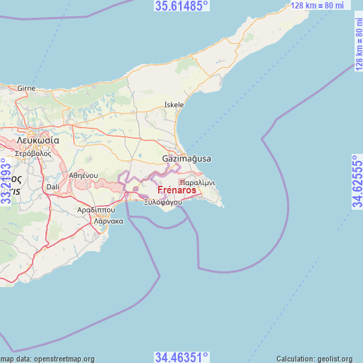
Frénaros GPS coordinates[2]
35° 2' 28.356" North, 33° 55' 20.712" East
| Map corner | latitude | longitude |
|---|---|---|
| Upper-left | 35.61485°, | 33.2193° |
| Center: | 35.04121°, | 33.92242° |
| Lower-right: | 34.46351°, | 34.62555° |
| Map W x H: | 128×128 km | = 79.5×79.5mi |
| max Lat: | 35.59719° ⇑30.8% North |
| Frénaros: | 35.04121° |
| min Lat: | ⇓69.2% South 34.66865° |
| min Long | Frénaros | max Long |
| 32.38166° | 33.92242° | 34.37916° |
| W 94%⇐ | ⇒6% E |
Elevation
Elevation of Frénaros is 76 m = 249 ft, and this is 132 m = 433 ft below average elevation for this country.
| Max E: |
1134 m = 3720 ft | 67.5% |
| Avg. | 208 m = 682 ft | |
| Frénaros | 76 m = 249 ft | |
Min E: |
4 m = 13 ft | 32.5% |
See also: Cyprus elevation on elevation.city.
Geographical zone
Frénaros is located in North temperate zone (between Tropic of Cancer and the Arctic Circle). Distance of this Northern Tropic circle is 1290.3 km =801.8 mi to South.| Distance of | km | miles | from Frénaros |
|---|---|---|---|
| North Pole | 6110.8 | 3797.1 | to North |
| Arctic Circle | 3505 | 2177.9 | to North |
| Tropic Cancer | 1290.3 | 801.8 | to South |
| Equator | 3896.2 | 2421 | to South |


Nearby cities:
15 places around Frénaros: (largest is in red/bold)
• Acherítou
8.6 km =5.3 mi,  319°
319°
• Avgórou
7.6 km =4.7 mi,  265°
265°
• Ayia Napa
9.8 km =6.1 mi,  132°
132°
• Derýneia
4.4 km =2.7 mi,  53°
53°
• Famagusta
8.9 km =5.5 mi,  9°
9°
• Liopétri
4.5 km =2.8 mi,  217°
217°
• Paralímni
5.4 km =3.4 mi,  92°
92°
• Protaras
12.8 km =8 mi,  104°
104°
• Pérgamos
19.5 km =12.1 mi, 270°
• Pýla
21.2 km =13.2 mi,  261°
261°
• Tríkomo
27.4 km =17 mi,  354°
354°
• Voróklini
25.2 km =15.7 mi, 255°
• Xylofágou
9.8 km =6.1 mi, 223°
• Xylotymbou
16.6 km =10.3 mi, 260°
• Áchna
12.7 km =7.9 mi,  277°
277°
Sources, notices
• [Note1] Compared only with cities in Cyprus existing in our database
• [Src1] Map data: © OpenStreetMap contributors (CC-BY-SA)
• [Src2] Other city data from geonames.org with taken over terms of usage.
• [Src3] Geographical zone / Annual Mean Temperature by Robert A. Rohde @ Wikipedia
