Famagusta geodata
Famagusta (Ammochostos) is a seat of a first-order administrative division; located in Cyprus in Asia/Famagusta (GMT+2) time zone. With population of 42,526 people, there are 3 cities with bigger population in this country. Compared to other cities in Cyprus, 87.2% of cities are located further ↓South; 94.9% of cities are located further ←West and 95.7% of cities have higher elevation than Famagusta. Note1


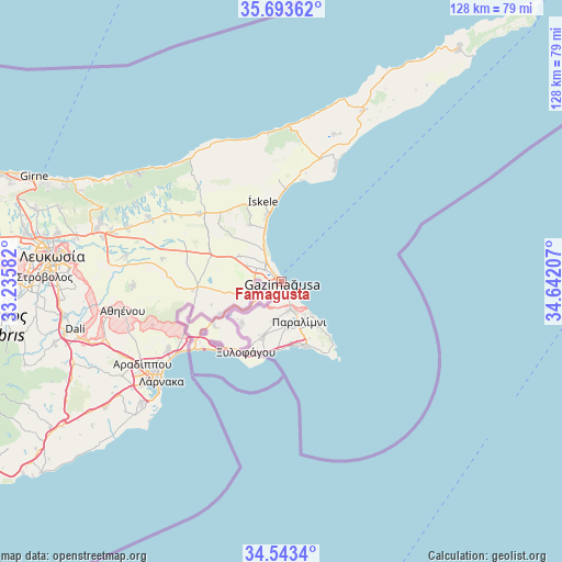
Famagusta GPS coordinates[2]
35° 7' 13.944" North, 33° 56' 20.184" East
| Map corner | latitude | longitude |
|---|---|---|
| Upper-left | 35.69362°, | 33.23582° |
| Center: | 35.12054°, | 33.93894° |
| Lower-right: | 34.5434°, | 34.64207° |
| Map W x H: | 127.9×127.9 km | = 79.5×79.5mi |
| max Lat: | 35.59719° ⇑12.8% North |
| Famagusta: | 35.12054° |
| min Lat: | ⇓87.2% South 34.66865° |
| min Long | Famagusta | max Long |
| 32.38166° | 33.93894° | 34.37916° |
| W 94.9%⇐ | ⇒5.1% E |
Elevation
Elevation of Famagusta is 14 m = 46 ft, and this is 194 m = 636 ft below average elevation for this country.
| Max E: |
1134 m = 3720 ft | 95.7% |
| Avg. | 208 m = 682 ft | |
| Famagusta | 14 m = 46 ft | |
Min E: |
4 m = 13 ft | 4.3% |
See also: Famagusta elevation on elevation.city.
Geographical zone
Famagusta is located in North temperate zone (between Tropic of Cancer and the Arctic Circle). Distance of this Northern Tropic circle is 1299.1 km =807.2 mi to South.| Distance of | km | miles | from Famagusta |
|---|---|---|---|
| North Pole | 6102 | 3791.6 | to North |
| Arctic Circle | 3496.1 | 2172.4 | to North |
| Tropic Cancer | 1299.1 | 807.2 | to South |
| Equator | 3905 | 2426.5 | to South |


Nearby cities:
15 places around Famagusta: (largest is in red/bold)
• Acherítou
7.4 km =4.6 mi,  252°
252°
• Avgórou
13.1 km =8.1 mi,  224°
224°
• Ayia Napa
16.4 km =10.2 mi,  159°
159°
• Derýneia
6.5 km =4 mi, 162°
• Frénaros
8.9 km =5.5 mi,  189°
189°
• Lefkónoiko
24.4 km =15.2 mi,  309°
309°
• Liopétri
13.1 km =8.1 mi,  198°
198°
• Paralímni
9.8 km =6.1 mi, 156°
• Protaras
16.2 km =10.1 mi,  137°
137°
• Pérgamos
22.7 km =14.1 mi, 247°
• Pýla
25.5 km =15.8 mi,  241°
241°
• Tríkomo
18.9 km =11.7 mi,  346°
346°
• Xylofágou
17.9 km =11.1 mi,  207°
207°
• Xylotymbou
21.3 km =13.2 mi, 237°
• Áchna
15.9 km =9.9 mi, 242°
In other languages:
- In France: Famagouste
- In Italian: Famagosta
- In Russian: Фамагуста
- In Chinese: 法马古斯塔
Sources, notices
• [Note1] Compared only with cities in Cyprus existing in our database
• [Src1] Map data: © OpenStreetMap contributors (CC-BY-SA)
• [Src2] Other city data from geonames.org with taken over terms of usage.
• [Src3] Geographical zone / Annual Mean Temperature by Robert A. Rohde @ Wikipedia
