Acherítou geodata
Acherítou (Ammochostos) is a populated place; located in Cyprus in Asia/Famagusta (GMT+2) time zone. With population of 1,721 people, there are 54 cities with bigger population in this country. Compared to other cities in Cyprus, 82.1% of cities are located further ↓South; 91.5% of cities are located further ←West and 91.5% of cities have higher elevation than Acherítou. Note1


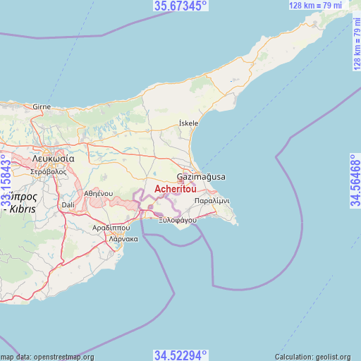
Acherítou GPS coordinates[2]
35° 6' 0.792" North, 33° 51' 41.58" East
| Map corner | latitude | longitude |
|---|---|---|
| Upper-left | 35.67345°, | 33.15843° |
| Center: | 35.10022°, | 33.86155° |
| Lower-right: | 34.52294°, | 34.56468° |
| Map W x H: | 127.9×127.9 km | = 79.5×79.5mi |
| max Lat: | 35.59719° ⇑17.9% North |
| Acherítou: | 35.10022° |
| min Lat: | ⇓82.1% South 34.66865° |
| min Long | Acherítou | max Long |
| 32.38166° | 33.86155° | 34.37916° |
| W 91.5%⇐ | ⇒8.5% E |
Elevation
Elevation of Acherítou is 23 m = 75 ft, and this is 185 m = 607 ft below average elevation for this country.
| Max E: |
1134 m = 3720 ft | 91.5% |
| Avg. | 208 m = 682 ft | |
| Acherítou | 23 m = 75 ft | |
Min E: |
4 m = 13 ft | 8.5% |
See also: Cyprus elevation on elevation.city.
Geographical zone
Acherítou is located in North temperate zone (between Tropic of Cancer and the Arctic Circle). Distance of this Northern Tropic circle is 1296.9 km =805.9 mi to South.| Distance of | km | miles | from Acherítou |
|---|---|---|---|
| North Pole | 6104.3 | 3793 | to North |
| Arctic Circle | 3498.4 | 2173.8 | to North |
| Tropic Cancer | 1296.9 | 805.9 | to South |
| Equator | 3902.8 | 2425.1 | to South |


Nearby cities:
15 places around Acherítou: (largest is in red/bold)
• Avgórou
7.4 km =4.6 mi,  195°
195°
• Ayia Napa
18.3 km =11.4 mi,  135°
135°
• Derýneia
9.9 km =6.2 mi,  113°
113°
• Famagusta
7.4 km =4.6 mi,  72°
72°
• Frénaros
8.6 km =5.3 mi, 139°
• Lefkónoiko
21.3 km =13.2 mi,  326°
326°
• Liopétri
10.5 km =6.5 mi,  164°
164°
• Paralímni
12.9 km =8 mi,  121°
121°
• Protaras
20.4 km =12.7 mi, 118°
• Pérgamos
15.4 km =9.6 mi,  244°
244°
• Pýla
18.3 km =11.4 mi, 237°
• Tríkomo
20.9 km =13 mi,  7°
7°
• Xylofágou
13.7 km =8.5 mi,  184°
184°
• Xylotymbou
14.2 km =8.8 mi,  229°
229°
• Áchna
8.7 km =5.4 mi, 234°
Sources, notices
• [Note1] Compared only with cities in Cyprus existing in our database
• [Src1] Map data: © OpenStreetMap contributors (CC-BY-SA)
• [Src2] Other city data from geonames.org with taken over terms of usage.
• [Src3] Geographical zone / Annual Mean Temperature by Robert A. Rohde @ Wikipedia
