Ayia Napa geodata
Ayia Napa (Ammochostos) is a populated place; located in Cyprus in Asia/Famagusta (GMT+2) time zone. With population of 2,798 people, there are 39 cities with bigger population in this country. Compared to other cities in Cyprus, 53.8% of cities are located further ↓South; 97.4% of cities are located further ←West and 100% of cities have higher elevation than Ayia Napa. Note1


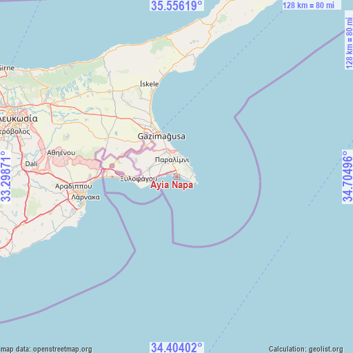
Ayia Napa GPS coordinates[2]
34° 58' 55.668" North, 34° 0' 6.588" East
| Map corner | latitude | longitude |
|---|---|---|
| Upper-left | 35.55619°, | 33.29871° |
| Center: | 34.98213°, | 34.00183° |
| Lower-right: | 34.40402°, | 34.70496° |
| Map W x H: | 128.1×128.1 km | = 79.6×79.6mi |
| max Lat: | 35.59719° ⇑46.2% North |
| Ayia Napa: | 34.98213° |
| min Lat: | ⇓53.8% South 34.66865° |
| min Long | Ayia Napa | max Long |
| 32.38166° | 34.00183° | 34.37916° |
| W 97.4%⇐ | ⇒2.6% E |
Elevation
Elevation of Ayia Napa is 4 m = 13 ft, and this is 204 m = 669 ft below average elevation for this country.
| Max E: |
1134 m = 3720 ft | 100% |
| Avg. | 208 m = 682 ft | |
| Ayia Napa | 4 m = 13 ft | |
Min E: |
4 m = 13 ft | 0% |
See also: Cyprus elevation on elevation.city.
Geographical zone
Ayia Napa is located in North temperate zone (between Tropic of Cancer and the Arctic Circle). Distance of this Northern Tropic circle is 1283.7 km =797.7 mi to South.| Distance of | km | miles | from Ayia Napa |
|---|---|---|---|
| North Pole | 6117.4 | 3801.2 | to North |
| Arctic Circle | 3511.5 | 2181.9 | to North |
| Tropic Cancer | 1283.7 | 797.7 | to South |
| Equator | 3889.6 | 2416.9 | to South |


Nearby cities:
15 places around Ayia Napa: (largest is in red/bold)
• Acherítou
18.3 km =11.4 mi,  315°
315°
• Avgórou
16 km =9.9 mi,  292°
292°
• Derýneia
9.9 km =6.2 mi,  337°
337°
• Famagusta
16.4 km =10.2 mi, 339°
• Frénaros
9.8 km =6.1 mi,  312°
312°
• Liopétri
10.4 km =6.5 mi, 286°
• Livádia
34.4 km =21.4 mi,  264°
264°
• Paralímni
6.6 km =4.1 mi, 344°
• Protaras
6.2 km =3.9 mi,  56°
56°
• Pérgamos
27.5 km =17.1 mi,  283°
283°
• Pýla
28.4 km =17.6 mi, 276°
• Voróklini
31.7 km =19.7 mi,  270°
270°
• Xylofágou
13.9 km =8.6 mi, 267°
• Xylotymbou
23.9 km =14.9 mi, 279°
• Áchna
21.4 km =13.3 mi, 292°
Sources, notices
• [Note1] Compared only with cities in Cyprus existing in our database
• [Src1] Map data: © OpenStreetMap contributors (CC-BY-SA)
• [Src2] Other city data from geonames.org with taken over terms of usage.
• [Src3] Geographical zone / Annual Mean Temperature by Robert A. Rohde @ Wikipedia
