Derýneia geodata
Derýneia (Ammochostos) is a populated place; located in Cyprus in Asia/Famagusta (GMT+3) time zone. With population of 5,161 people, there are 22 cities with bigger population in this country. Compared to other cities in Cyprus, 77.8% of cities are located further ↓South; 95.7% of cities are located further ←West and 70.9% of cities have higher elevation than Derýneia. Note1


Derýneia GPS coordinates[2]
35° 3' 53.424" North, 33° 57' 38.988" East
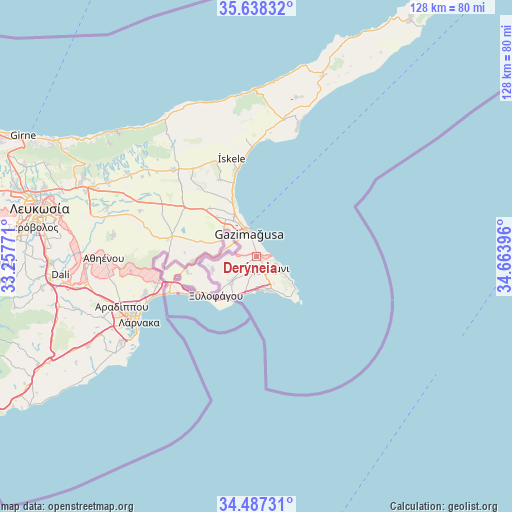
| Map corner | latitude | longitude |
|---|---|---|
| Upper-left | 35.63832°, | 33.25771° |
| Center: | 35.06484°, | 33.96083° |
| Lower-right: | 34.48731°, | 34.66396° |
| Map W x H: | 128×128 km | = 79.5×79.5mi |
| max Lat: | 35.59719° ⇑22.2% North |
| Derýneia: | 35.06484° |
| min Lat: | ⇓77.8% South 34.66865° |
| min Long | Derýneia | max Long |
| 32.38166° | 33.96083° | 34.37916° |
| W 95.7%⇐ | ⇒4.3% E |
Elevation
Elevation of Derýneia is 67 m = 220 ft, and this is 141 m = 463 ft below average elevation for this country.
| Max E: |
1134 m = 3720 ft | 70.9% |
| Avg. | 208 m = 682 ft | |
| Derýneia | 67 m = 220 ft | |
Min E: |
4 m = 13 ft | 29.1% |
See also: Cyprus elevation on elevation.city.
Geographical zone
Derýneia is located in North temperate zone (between Tropic of Cancer and the Arctic Circle). Distance of this Northern Tropic circle is 1292.9 km =803.4 mi to South.| Distance of | km | miles | from Derýneia |
|---|---|---|---|
| North Pole | 6108.2 | 3795.5 | to North |
| Arctic Circle | 3502.3 | 2176.2 | to North |
| Tropic Cancer | 1292.9 | 803.4 | to South |
| Equator | 3898.8 | 2422.6 | to South |


Nearby cities:
15 places around Derýneia: (largest is in red/bold)
• Acherítou
9.9 km =6.2 mi,  293°
293°
• Avgórou
11.5 km =7.1 mi,  253°
253°
• Ayia Napa
9.9 km =6.2 mi,  157°
157°
• Famagusta
6.5 km =4 mi,  342°
342°
• Frénaros
4.4 km =2.7 mi,  233°
233°
• Liopétri
8.8 km =5.5 mi,  224°
224°
• Paralímni
3.4 km =2.1 mi,  145°
145°
• Protaras
10.6 km =6.6 mi,  123°
123°
• Pérgamos
23.1 km =14.4 mi,  263°
263°
• Pýla
25.2 km =15.7 mi, 256°
• Tríkomo
25.4 km =15.8 mi,  345°
345°
• Voróklini
29.3 km =18.2 mi, 252°
• Xylofágou
14.1 km =8.8 mi, 226°
• Xylotymbou
20.6 km =12.8 mi, 255°
• Áchna
16.1 km =10 mi,  266°
266°
Sources, notices
• [Note1] Compared only with cities in Cyprus existing in our database
• [Src1] Map data: © OpenStreetMap contributors (CC-BY-SA)
• [Src2] Other city data from geonames.org with taken over terms of usage.
• [Src3] Geographical zone / Annual Mean Temperature by Robert A. Rohde @ Wikipedia
