Avgórou geodata
Avgórou (Ammochostos) is a populated place; located in Cyprus in Asia/Famagusta (GMT+3) time zone. With population of 4,177 people, there are 27 cities with bigger population in this country. Compared to other cities in Cyprus, 66.7% of cities are located further ↓South; 89.7% of cities are located further ←West and 81.2% of cities have higher elevation than Avgórou. Note1


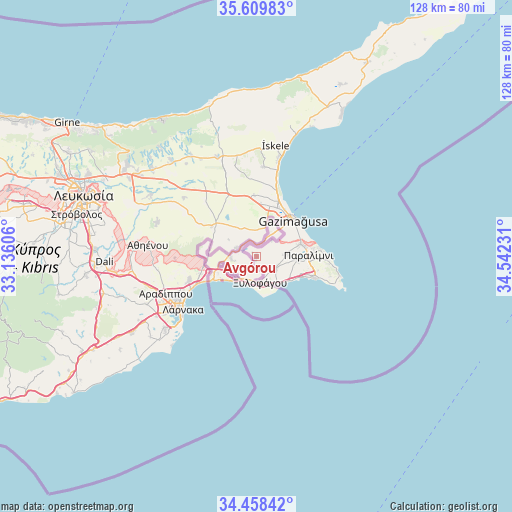
Avgórou GPS coordinates[2]
35° 2' 10.14" North, 33° 50' 21.048" East
| Map corner | latitude | longitude |
|---|---|---|
| Upper-left | 35.60983°, | 33.13606° |
| Center: | 35.03615°, | 33.83918° |
| Lower-right: | 34.45842°, | 34.54231° |
| Map W x H: | 128×128 km | = 79.5×79.5mi |
| max Lat: | 35.59719° ⇑33.3% North |
| Avgórou: | 35.03615° |
| min Lat: | ⇓66.7% South 34.66865° |
| min Long | Avgórou | max Long |
| 32.38166° | 33.83918° | 34.37916° |
| W 89.7%⇐ | ⇒10.3% E |
Elevation
Elevation of Avgórou is 41 m = 135 ft, and this is 167 m = 548 ft below average elevation for this country.
| Max E: |
1134 m = 3720 ft | 81.2% |
| Avg. | 208 m = 682 ft | |
| Avgórou | 41 m = 135 ft | |
Min E: |
4 m = 13 ft | 18.8% |
See also: Cyprus elevation on elevation.city.
Geographical zone
Avgórou is located in North temperate zone (between Tropic of Cancer and the Arctic Circle). Distance of this Northern Tropic circle is 1289.7 km =801.4 mi to South.| Distance of | km | miles | from Avgórou |
|---|---|---|---|
| North Pole | 6111.4 | 3797.4 | to North |
| Arctic Circle | 3505.5 | 2178.2 | to North |
| Tropic Cancer | 1289.7 | 801.4 | to South |
| Equator | 3895.7 | 2420.7 | to South |


Nearby cities:
15 places around Avgórou: (largest is in red/bold)
• Acherítou
7.4 km =4.6 mi,  15°
15°
• Ayia Napa
16 km =9.9 mi,  112°
112°
• Derýneia
11.5 km =7.1 mi,  73°
73°
• Famagusta
13.1 km =8.1 mi,  44°
44°
• Frénaros
7.6 km =4.7 mi,  85°
85°
• Liopétri
5.7 km =3.5 mi,  121°
121°
• Paralímni
13 km =8.1 mi, 88°
• Protaras
20.1 km =12.5 mi,  97°
97°
• Pérgamos
11.9 km =7.4 mi,  272°
272°
• Pýla
13.7 km =8.5 mi,  258°
258°
• Troúlloi
20.4 km =12.7 mi, 268°
• Voróklini
17.8 km =11.1 mi,  251°
251°
• Xylofágou
6.6 km =4.1 mi,  172°
172°
• Xylotymbou
9.1 km =5.7 mi, 256°
• Áchna
5.5 km =3.4 mi,  292°
292°
Sources, notices
• [Note1] Compared only with cities in Cyprus existing in our database
• [Src1] Map data: © OpenStreetMap contributors (CC-BY-SA)
• [Src2] Other city data from geonames.org with taken over terms of usage.
• [Src3] Geographical zone / Annual Mean Temperature by Robert A. Rohde @ Wikipedia
