Lefkónoiko geodata
Lefkónoiko (Ammochostos) is a populated place; located in Cyprus in Asia/Famagusta (GMT+2) time zone. With population of 3,187 people, there are 37 cities with bigger population in this country. Compared to other cities in Cyprus, 95.7% of cities are located further ↓South; 87.2% of cities are located further ←West and 71.8% of cities have higher elevation than Lefkónoiko. Note1


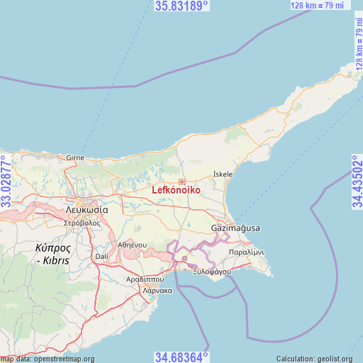
Lefkónoiko GPS coordinates[2]
35° 15' 35.28" North, 33° 43' 54.804" East
| Map corner | latitude | longitude |
|---|---|---|
| Upper-left | 35.83189°, | 33.02877° |
| Center: | 35.2598°, | 33.73189° |
| Lower-right: | 34.68364°, | 34.43502° |
| Map W x H: | 127.7×127.7 km | = 79.3×79.3mi |
| max Lat: | 35.59719° ⇑4.3% North |
| Lefkónoiko: | 35.2598° |
| min Lat: | ⇓95.7% South 34.66865° |
| min Long | Lefkónoiko | max Long |
| 32.38166° | 33.73189° | 34.37916° |
| W 87.2%⇐ | ⇒12.8% E |
Elevation
Elevation of Lefkónoiko is 62 m = 203 ft, and this is 146 m = 479 ft below average elevation for this country.
| Max E: |
1134 m = 3720 ft | 71.8% |
| Avg. | 208 m = 682 ft | |
| Lefkónoiko | 62 m = 203 ft | |
Min E: |
4 m = 13 ft | 28.2% |
See also: Cyprus elevation on elevation.city.
Geographical zone
Lefkónoiko is located in North temperate zone (between Tropic of Cancer and the Arctic Circle). Distance of this Northern Tropic circle is 1314.6 km =816.9 mi to South.| Distance of | km | miles | from Lefkónoiko |
|---|---|---|---|
| North Pole | 6086.5 | 3782 | to North |
| Arctic Circle | 3480.7 | 2162.8 | to North |
| Tropic Cancer | 1314.6 | 816.9 | to South |
| Equator | 3920.5 | 2436.1 | to South |


Nearby cities:
15 places around Lefkónoiko: (largest is in red/bold)
• Acherítou
21.3 km =13.2 mi,  146°
146°
• Athíenou
28 km =17.4 mi,  218°
218°
• Avgórou
26.7 km =16.6 mi,  158°
158°
• Derýneia
30 km =18.6 mi,  136°
136°
• Famagusta
24.4 km =15.2 mi,  129°
129°
• Frénaros
29.8 km =18.5 mi, 144°
• Géri
33.1 km =20.6 mi,  238°
238°
• Liopétri
31.5 km =19.6 mi, 152°
• Pérgamos
24.3 km =15.1 mi,  185°
185°
• Pýla
27.8 km =17.3 mi, 187°
• Troúlloi
27.5 km =17.1 mi,  202°
202°
• Tríkomo
14.8 km =9.2 mi,  78°
78°
• Voróklini
31.3 km =19.4 mi, 193°
• Xylotymbou
27 km =16.8 mi,  177°
177°
• Áchna
23.2 km =14.4 mi,  168°
168°
Sources, notices
• [Note1] Compared only with cities in Cyprus existing in our database
• [Src1] Map data: © OpenStreetMap contributors (CC-BY-SA)
• [Src2] Other city data from geonames.org with taken over terms of usage.
• [Src3] Geographical zone / Annual Mean Temperature by Robert A. Rohde @ Wikipedia
