Tindouf geodata
Tindouf is a seat of a first-order administrative division; located in Algeria in Africa/Algiers (GMT+1) time zone. With population of 45,966 people, there are 109 cities with bigger population in this country. Compared to other cities in Algeria, 98.1% of cities are located further ↑North; 100% of cities are located further →East and 55.4% of cities have lower elevation than Tindouf. Note1


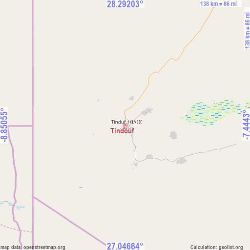
Tindouf GPS coordinates[2]
27° 40' 15.996" North, 8° 8' 50.748" West
| Map corner | latitude | longitude |
|---|---|---|
| Upper-left | 28.29203°, | -8.85055° |
| Center: | 27.67111°, | -8.14743° |
| Lower-right: | 27.04664°, | -7.4443° |
| Map W x H: | 138.5×138.5 km | = 86.1×86.1mi |
| max Lat: | 36.92917° ⇑98.1% North |
| Tindouf: | 27.67111° |
| min Lat: | ⇓1.9% South 22.785° |
| min Long | Tindouf | max Long |
| -8.14743° | -8.14743° | 8.46667° |
| W 0%⇐ | ⇒100% E |
Elevation
Elevation of Tindouf is 402 m = 1319 ft, and this is 36.5 m = 120 ft below average elevation for this country.
| Max E: |
1392 m = 4567 ft | 44.6% |
| Avg. | 438.5 m = 1439 ft | |
| Tindouf | 402 m = 1319 ft | |
Min E: |
5 m = 16 ft | 55.4% |
See also: Tindouf elevation on elevation.city.
Geographical zone
Tindouf is located in North temperate zone (between Tropic of Cancer and the Arctic Circle). Distance of this Northern Tropic circle is 470.8 km =292.5 mi to South.| Distance of | km | miles | from Tindouf |
|---|---|---|---|
| North Pole | 6930.3 | 4306.3 | to North |
| Arctic Circle | 4324.4 | 2687.1 | to North |
| Tropic Cancer | 470.8 | 292.5 | to South |
| Equator | 3076.7 | 1911.8 | to South |


Nearby cities:
15 places around Tindouf: (largest is in red/bold)
• Adrar
772.8 km =480.2 mi,  88°
88°
• Aoulef
915 km =568.6 mi, 94°
• Aïn Sefra
919.9 km =571.6 mi,  52°
52°
• Beni Mester
1023.7 km =636.1 mi,  38°
38°
• Béchar
721.5 km =448.3 mi, 52°
• Chetouane
1035.6 km =643.5 mi, 38°
• El Abiodh Sidi Cheikh
1016.3 km =631.5 mi,  55°
55°
• Hennaya
1033.8 km =642.4 mi, 38°
• Mansoûra
1027.9 km =638.7 mi, 38°
• Naama
974.2 km =605.3 mi, 50°
• Nedroma
1017.2 km =632.1 mi, 36°
• Reggane
829.4 km =515.4 mi,  97°
97°
• Sebdou
1009.6 km =627.3 mi, 39°
• Timimoun
837.7 km =520.5 mi,  77°
77°
• Tlemcen
1030.8 km =640.5 mi, 38°
Sources, notices
• [Note1] Compared only with cities in Algeria existing in our database
• [Src1] Map data: © OpenStreetMap contributors (CC-BY-SA)
• [Src2] Other city data from geonames.org with taken over terms of usage.
• [Src3] Geographical zone / Annual Mean Temperature by Robert A. Rohde @ Wikipedia
