Naama geodata
Naama is a seat of a first-order administrative division; located in Algeria in Africa/Algiers (GMT+1) time zone. With population of 8,390 people, there are 251 cities with bigger population in this country. Compared to other cities in Algeria, 91.5% of cities are located further ↑North; 88.8% of cities are located further →East and 98.1% of cities have lower elevation than Naama. Note1


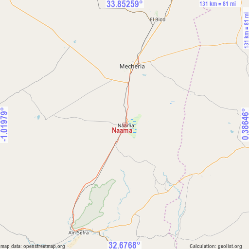
Naama GPS coordinates[2]
33° 16' 0.012" North, 0° 19' 0.012" West
| Map corner | latitude | longitude |
|---|---|---|
| Upper-left | 33.85259°, | -1.01979° |
| Center: | 33.26667°, | -0.31667° |
| Lower-right: | 32.6768°, | 0.38646° |
| Map W x H: | 130.7×130.7 km | = 81.2×81.2mi |
| max Lat: | 36.92917° ⇑91.5% North |
| Naama: | 33.26667° |
| min Lat: | ⇓8.5% South 22.785° |
| min Long | Naama | max Long |
| -8.14743° | -0.31667° | 8.46667° |
| W 11.2%⇐ | ⇒88.8% E |
Elevation
Elevation of Naama is 1169 m = 3835 ft, and this is 730.5 m = 2397 ft above average elevation for this country.
| Max E: |
1392 m = 4567 ft | 1.9% |
| Naama | 1169 m 3835 ft | |
| Avg. | 438.5 m = 1439 ft | |
Min E: |
5 m = 16 ft | 98.1% |
See also: Algeria elevation on elevation.city.
Geographical zone
Naama is located in North temperate zone (between Tropic of Cancer and the Arctic Circle). Distance of this Northern Tropic circle is 1093 km =679.2 mi to South.| Distance of | km | miles | from Naama |
|---|---|---|---|
| North Pole | 6308.2 | 3919.7 | to North |
| Arctic Circle | 3702.3 | 2300.5 | to North |
| Tropic Cancer | 1093 | 679.2 | to South |
| Equator | 3698.9 | 2298.4 | to South |


Nearby cities:
15 places around Naama: (largest is in red/bold)
• Aïn Sefra
62.6 km =38.9 mi,  203°
203°
• Beni Mester
205.4 km =127.6 mi,  330°
330°
• Brezina
148 km =92 mi,  97°
97°
• Chetouane
204.8 km =127.3 mi, 333°
• Djebilet Rosfa
206.8 km =128.5 mi,  30°
30°
• El Abiodh Sidi Cheikh
90.7 km =56.4 mi,  117°
117°
• El Bayadh
132.3 km =82.2 mi,  69°
69°
• Hennaya
210.8 km =131 mi, 332°
• Mansoûra
200.8 km =124.8 mi, 332°
• Ouled Mimoun
193.7 km =120.4 mi,  340°
340°
• Saïda
179.1 km =111.3 mi,  13°
13°
• Sebdou
178.8 km =111.1 mi, 328°
• Sidi Senoussi سيدي سنوسي
205.3 km =127.6 mi, 339°
• Tlemcen
201.4 km =125.1 mi, 332°
• ’Aïn el Hadjar
171.2 km =106.4 mi, 14°
Sources, notices
• [Note1] Compared only with cities in Algeria existing in our database
• [Src1] Map data: © OpenStreetMap contributors (CC-BY-SA)
• [Src2] Other city data from geonames.org with taken over terms of usage.
• [Src3] Geographical zone / Annual Mean Temperature by Robert A. Rohde @ Wikipedia
