El Abiodh Sidi Cheikh geodata
El Abiodh Sidi Cheikh (El Bayadh) is a populated place; located in Algeria in Africa/Algiers (GMT+1) time zone. With population of 39,283 people, there are 132 cities with bigger population in this country. Compared to other cities in Algeria, 93.4% of cities are located further ↑North; 84.1% of cities are located further →East and 82.6% of cities have lower elevation than El Abiodh Sidi Cheikh. Note1
Current local time in El Abiodh Sidi Cheikh:
02:20 AM, WednesdayDifference from your time zone: hours


El Abiodh Sidi Cheikh GPS coordinates[2]
32° 53' 34.8" North, 0° 32' 54.204" East
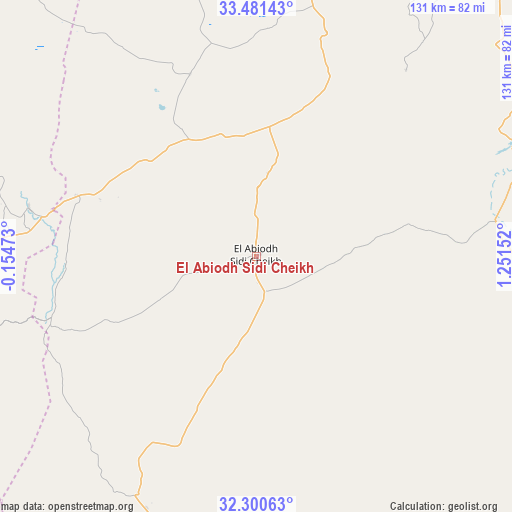
| Map corner | latitude | longitude |
|---|---|---|
| Upper-left | 33.48143°, | -0.15473° |
| Center: | 32.893°, | 0.54839° |
| Lower-right: | 32.30063°, | 1.25152° |
| Map W x H: | 131.3×131.3 km | = 81.6×81.6mi |
| max Lat: | 36.92917° ⇑93.4% North |
| El Abiodh Sidi Cheikh: | 32.893° |
| min Lat: | ⇓6.6% South 22.785° |
| min Long | El Abiodh Sidi | max Long |
| -8.14743° | 0.54839° | 8.46667° |
| W 15.9%⇐ | ⇒84.1% E |
Elevation
Elevation of El Abiodh Sidi Cheikh is 903 m = 2963 ft, and this is 464.5 m = 1524 ft above average elevation for this country.
| Max E: |
1392 m = 4567 ft | 17.4% |
| El Abiodh Sidi Cheikh | 903 m 2963 ft | |
| Avg. | 438.5 m = 1439 ft | |
Min E: |
5 m = 16 ft | 82.6% |
See also: Algeria elevation on elevation.city.
Geographical zone
El Abiodh Sidi Cheikh is located in North temperate zone (between Tropic of Cancer and the Arctic Circle). Distance of this Northern Tropic circle is 1051.4 km =653.3 mi to South.| Distance of | km | miles | from El Abiodh Sidi Cheikh |
|---|---|---|---|
| North Pole | 6349.7 | 3945.5 | to North |
| Arctic Circle | 3743.8 | 2326.3 | to North |
| Tropic Cancer | 1051.4 | 653.3 | to South |
| Equator | 3657.4 | 2272.6 | to South |


Nearby cities:
15 places around El Abiodh Sidi Cheikh: (largest is in red/bold)
• Aflou
197.9 km =123 mi,  46°
46°
• Aïn Sefra
106.9 km =66.4 mi,  261°
261°
• Brezina
70.3 km =43.7 mi,  70°
70°
• Djebilet Rosfa
220.7 km =137.1 mi,  6°
6°
• El Bayadh
98.2 km =61 mi,  26°
26°
• El Idrissia
251.7 km =156.4 mi, 46°
• Frenda
245.9 km =152.8 mi, 10°
• Laghouat
237.6 km =147.6 mi,  64°
64°
• Naama
90.7 km =56.4 mi,  297°
297°
• Ouled Mimoun
267.1 km =166 mi,  326°
326°
• Saïda
218.5 km =135.8 mi,  350°
350°
• Sebdou
260.4 km =161.8 mi,  318°
318°
• Sougueur
269.5 km =167.5 mi,  18°
18°
• ’Aïn Deheb
235.5 km =146.3 mi, 23°
• ’Aïn el Hadjar
210.7 km =130.9 mi, 349°
Sources, notices
• [Note1] Compared only with cities in Algeria existing in our database
• [Src1] Map data: © OpenStreetMap contributors (CC-BY-SA)
• [Src2] Other city data from geonames.org with taken over terms of usage.
• [Src3] Geographical zone / Annual Mean Temperature by Robert A. Rohde @ Wikipedia
