Béchar geodata
Béchar is a seat of a first-order administrative division; located in Algeria in Africa/Algiers (GMT+1) time zone. With population of 143,382 people, there are 25 cities with bigger population in this country. Compared to other cities in Algeria, 96.9% of cities are located further ↑North; 99.6% of cities are located further →East and 74.8% of cities have lower elevation than Béchar. Note1


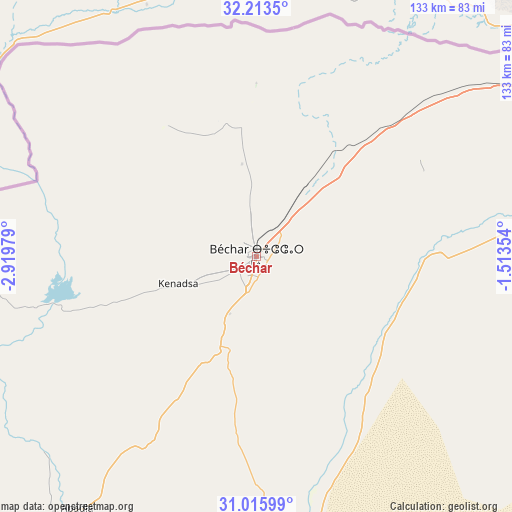
Béchar GPS coordinates[2]
31° 37' 0.012" North, 2° 13' 0.012" West
| Map corner | latitude | longitude |
|---|---|---|
| Upper-left | 32.2135°, | -2.91979° |
| Center: | 31.61667°, | -2.21667° |
| Lower-right: | 31.01599°, | -1.51354° |
| Map W x H: | 133.2×133.2 km | = 82.8×82.8mi |
| max Lat: | 36.92917° ⇑96.9% North |
| Béchar: | 31.61667° |
| min Lat: | ⇓3.1% South 22.785° |
| min Long | Béchar | max Long |
| -8.14743° | -2.21667° | 8.46667° |
| W 0.4%⇐ | ⇒99.6% E |
Elevation
Elevation of Béchar is 780 m = 2559 ft, and this is 341.5 m = 1120 ft above average elevation for this country.
| Max E: |
1392 m = 4567 ft | 25.2% |
| Béchar | 780 m 2559 ft | |
| Avg. | 438.5 m = 1439 ft | |
Min E: |
5 m = 16 ft | 74.8% |
See also: Béchar elevation on elevation.city.
Geographical zone
Béchar is located in North temperate zone (between Tropic of Cancer and the Arctic Circle). Distance of this Northern Tropic circle is 909.5 km =565.1 mi to South.| Distance of | km | miles | from Béchar |
|---|---|---|---|
| North Pole | 6491.6 | 4033.7 | to North |
| Arctic Circle | 3885.7 | 2414.5 | to North |
| Tropic Cancer | 909.5 | 565.1 | to South |
| Equator | 3515.4 | 2184.4 | to South |


Nearby cities:
15 places around Béchar: (largest is in red/bold)
• Aïn Sefra
198.8 km =123.5 mi,  50°
50°
• Beni Mester
369.2 km =229.4 mi,  11°
11°
• Brezina
365.8 km =227.3 mi,  63°
63°
• Chetouane
377.3 km =234.4 mi, 13°
• El Abiodh Sidi Cheikh
296.2 km =184.1 mi, 61°
• El Bayadh
380.2 km =236.2 mi, 52°
• Hennaya
379.1 km =235.6 mi, 12°
• Mansoûra
369.9 km =229.8 mi, 12°
• Naama
255.8 km =158.9 mi,  44°
44°
• Nedroma
380.2 km =236.2 mi, 6°
• Ouled Mimoun
381.8 km =237.2 mi,  16°
16°
• Remchi
389.9 km =242.3 mi, 10°
• Sebdou
345.8 km =214.9 mi, 13°
• Timimoun
351.4 km =218.3 mi,  138°
138°
• Tlemcen
372.2 km =231.3 mi, 13°
Sources, notices
• [Note1] Compared only with cities in Algeria existing in our database
• [Src1] Map data: © OpenStreetMap contributors (CC-BY-SA)
• [Src2] Other city data from geonames.org with taken over terms of usage.
• [Src3] Geographical zone / Annual Mean Temperature by Robert A. Rohde @ Wikipedia
