Salah Bey geodata
Salah Bey (Sétif) is a populated place; located in Algeria in Africa/Algiers (GMT+1) time zone. With population of 23,339 people, there are 207 cities with bigger population in this country. Compared to other cities in Algeria, 57% of cities are located further ↑North; 72.1% of cities are located further ←West and 88% of cities have lower elevation than Salah Bey. Note1


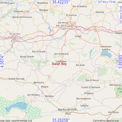
Salah Bey GPS coordinates[2]
35° 51' 16.236" North, 5° 17' 25.908" East
| Map corner | latitude | longitude |
|---|---|---|
| Upper-left | 36.42235°, | 4.5874° |
| Center: | 35.85451°, | 5.29053° |
| Lower-right: | 35.28258°, | 5.99365° |
| Map W x H: | 126.7×126.7 km | = 78.7×78.7mi |
| max Lat: | 36.92917° ⇑57% North |
| Salah Bey: | 35.85451° |
| min Lat: | ⇓43% South 22.785° |
| min Long | Salah Bey | max Long |
| -8.14743° | 5.29053° | 8.46667° |
| W 72.1%⇐ | ⇒27.9% E |
Elevation
Elevation of Salah Bey is 976 m = 3202 ft, and this is 537.5 m = 1763 ft above average elevation for this country.
| Max E: |
1392 m = 4567 ft | 12% |
| Salah Bey | 976 m 3202 ft | |
| Avg. | 438.5 m = 1439 ft | |
Min E: |
5 m = 16 ft | 88% |
See also: Algeria elevation on elevation.city.
Geographical zone
Salah Bey is located in North temperate zone (between Tropic of Cancer and the Arctic Circle). Distance of this Northern Tropic circle is 1380.7 km =857.9 mi to South.| Distance of | km | miles | from Salah Bey |
|---|---|---|---|
| North Pole | 6020.4 | 3740.9 | to North |
| Arctic Circle | 3414.5 | 2121.7 | to North |
| Tropic Cancer | 1380.7 | 857.9 | to South |
| Equator | 3986.6 | 2477.2 | to South |


Nearby cities:
15 places around Salah Bey: (largest is in red/bold)
• Aïn Arnat
37 km =23 mi,  3°
3°
• BABOR - VILLE
74.1 km =46 mi,  17°
17°
• Barika
52.2 km =32.4 mi,  172°
172°
• Bordj Bou Arreridj
53.5 km =33.2 mi,  297°
297°
• Bordj Ghdir
35.7 km =22.2 mi,  278°
278°
• Bordj Zemoura
60.8 km =37.8 mi,  320°
320°
• Bougaa
56.2 km =34.9 mi,  341°
341°
• Boumagueur
45.5 km =28.3 mi,  148°
148°
• El Achir
64.1 km =39.8 mi,  291°
291°
• El Eulma
48.9 km =30.4 mi,  47°
47°
• Merouana
61.3 km =38.1 mi,  113°
113°
• M’Sila
69.5 km =43.2 mi,  256°
256°
• Râs el Aïoun
37.8 km =23.5 mi,  122°
122°
• Râs el Oued
25.4 km =15.8 mi, 293°
• Sétif
39 km =24.2 mi, 16°
Sources, notices
• [Note1] Compared only with cities in Algeria existing in our database
• [Src1] Map data: © OpenStreetMap contributors (CC-BY-SA)
• [Src2] Other city data from geonames.org with taken over terms of usage.
• [Src3] Geographical zone / Annual Mean Temperature by Robert A. Rohde @ Wikipedia
