Quandeba geodata
Quandeba (Maekel) is a farm village; located in Eritrea in Africa/Asmara (GMT+3) time zone. With population of 1,000 people, there are 11 cities with bigger population in this country. Compared to other cities in Eritrea, 75% of cities are located further ↓South; 50% of cities are located further ←West and 100% of cities have lower elevation than Quandeba. Note1


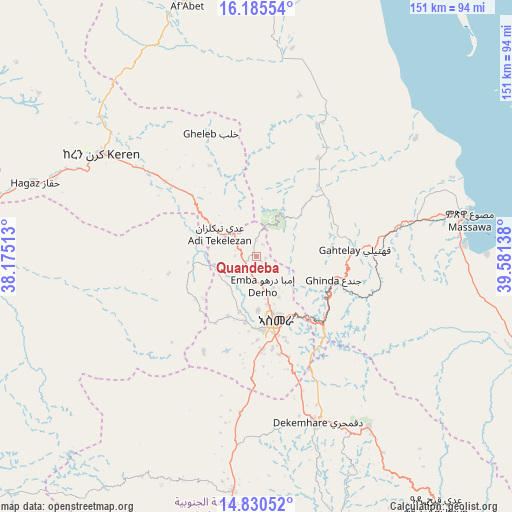
Quandeba GPS coordinates[2]
15° 30' 32.904" North, 38° 52' 41.7" East
| Map corner | latitude | longitude |
|---|---|---|
| Upper-left | 16.18554°, | 38.17513° |
| Center: | 15.50914°, | 38.87825° |
| Lower-right: | 14.83052°, | 39.58138° |
| Map W x H: | 150.7×150.7 km | = 93.6×93.6mi |
| max Lat: | 15.77792° ⇑25% North |
| Quandeba: | 15.50914° |
| min Lat: | ⇓75% South 13.00917° |
| min Long | Quandeba | max Long |
| 36.6575° | 38.87825° | 42.73944° |
| W 50%⇐ | ⇒50% E |
Elevation
Elevation of Quandeba is 2528 m = 8294 ft, and this is 1239.5 m = 4067 ft above average elevation for this country.
| Max E: |
2528 m = 8294 ft | 0% |
| Quandeba | 2528 m 8294 ft | |
| Avg. | 1288.5 m = 4227 ft | |
Min E: |
7 m = 23 ft | 100% |
See also: Eritrea elevation on elevation.city.
Geographical zone
Quandeba is located in North Torrid zone (between Equator and Tropic of Cancer). Distance of this Northern Tropic circle is 881.5 km =547.7 mi to North.| Distance of | km | miles | from Quandeba |
|---|---|---|---|
| North Pole | 8282.6 | 5146.6 | to North |
| Arctic Circle | 5676.7 | 3527.3 | to North |
| Tropic Cancer | 881.5 | 547.7 | to North |
| Equator | 1724.5 | 1071.6 | to South |


Nearby cities:
11 places around Quandeba: (largest is in red/bold)
• Adi Keyh
91.3 km =56.7 mi,  144°
144°
• Ak’ordat
106.7 km =66.3 mi,  272°
272°
• Asmara
19.9 km =12.4 mi,  163°
163°
• Barentu
145.2 km =90.2 mi,  252°
252°
• Dek’emhāre
52.1 km =32.4 mi, 159°
• Edd
350 km =217.5 mi,  120°
120°
• Keren
54.6 km =33.9 mi,  303°
303°
• Mai-Mne
113.6 km =70.6 mi,  200°
200°
• Massawa
64.8 km =40.3 mi,  80°
80°
• Mendefera
69.5 km =43.2 mi,  185°
185°
• Teseney
242.3 km =150.6 mi,  259°
259°
Sources, notices
• [Note1] Compared only with cities in Eritrea existing in our database
• [Src1] Map data: © OpenStreetMap contributors (CC-BY-SA)
• [Src2] Other city data from geonames.org with taken over terms of usage.
• [Src3] Geographical zone / Annual Mean Temperature by Robert A. Rohde @ Wikipedia
