Dek’emhāre geodata
Dek’emhāre (Debub) is a populated place; located in Eritrea in Africa/Asmara (GMT+3) time zone. With population of 10,959 people, there are 8 cities with bigger population in this country. Compared to other cities in Eritrea, 58.3% of cities are located further ↑North; 66.7% of cities are located further ←West and 75% of cities have lower elevation than Dek’emhāre. Note1


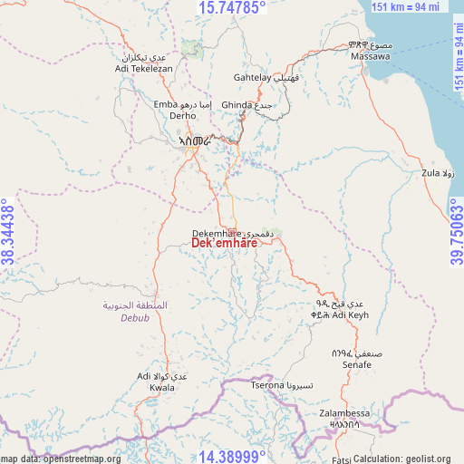
Dek’emhāre GPS coordinates[2]
15° 4' 12" North, 39° 2' 51" East
| Map corner | latitude | longitude |
|---|---|---|
| Upper-left | 15.74785°, | 38.34438° |
| Center: | 15.07°, | 39.0475° |
| Lower-right: | 14.38999°, | 39.75063° |
| Map W x H: | 151×151 km | = 93.8×93.8mi |
| max Lat: | 15.77792° ⇑58.3% North |
| Dek’emhāre: | 15.07° |
| min Lat: | ⇓41.7% South 13.00917° |
| min Long | Dek’emhāre | max Long |
| 36.6575° | 39.0475° | 42.73944° |
| W 66.7%⇐ | ⇒33.3% E |
Elevation
Elevation of Dek’emhāre is 2019 m = 6624 ft, and this is 730.5 m = 2397 ft above average elevation for this country.
| Max E: |
2528 m = 8294 ft | 25% |
| Dek’emhāre | 2019 m 6624 ft | |
| Avg. | 1288.5 m = 4227 ft | |
Min E: |
7 m = 23 ft | 75% |
See also: Eritrea elevation on elevation.city.
Geographical zone
Dek’emhāre is located in North Torrid zone (between Equator and Tropic of Cancer). Distance of this Northern Tropic circle is 930.3 km =578.1 mi to North.| Distance of | km | miles | from Dek’emhāre |
|---|---|---|---|
| North Pole | 8331.4 | 5176.9 | to North |
| Arctic Circle | 5725.5 | 3557.7 | to North |
| Tropic Cancer | 930.3 | 578.1 | to North |
| Equator | 1675.6 | 1041.2 | to South |


Nearby cities:
11 places around Dek’emhāre: (largest is in red/bold)
• Adi Keyh
43.4 km =27 mi,  125°
125°
• Ak’ordat
135.7 km =84.3 mi,  293°
293°
• Asmara
32.3 km =20.1 mi,  337°
337°
• Barentu
156.5 km =97.2 mi,  271°
271°
• Edd
311.7 km =193.7 mi,  113°
113°
• Keren
101.4 km =63 mi,  320°
320°
• Mai-Mne
81.9 km =50.9 mi,  225°
225°
• Massawa
75.3 km =46.8 mi,  37°
37°
• Mendefera
32.2 km =20 mi, 230°
• Quandeba
52.1 km =32.4 mi, 339°
• Teseney
256.6 km =159.4 mi, 270°
Sources, notices
• [Note1] Compared only with cities in Eritrea existing in our database
• [Src1] Map data: © OpenStreetMap contributors (CC-BY-SA)
• [Src2] Other city data from geonames.org with taken over terms of usage.
• [Src3] Geographical zone / Annual Mean Temperature by Robert A. Rohde @ Wikipedia
