Barentu geodata
Barentu (Gash-Barka) is a seat of a first-order administrative division; located in Eritrea in Africa/Asmara (GMT+3) time zone. With population of 15,891 people, there are 5 cities with bigger population in this country. Compared to other cities in Eritrea, 50% of cities are located further ↓South; 91.7% of cities are located further →East and 58.3% of cities have higher elevation than Barentu. Note1


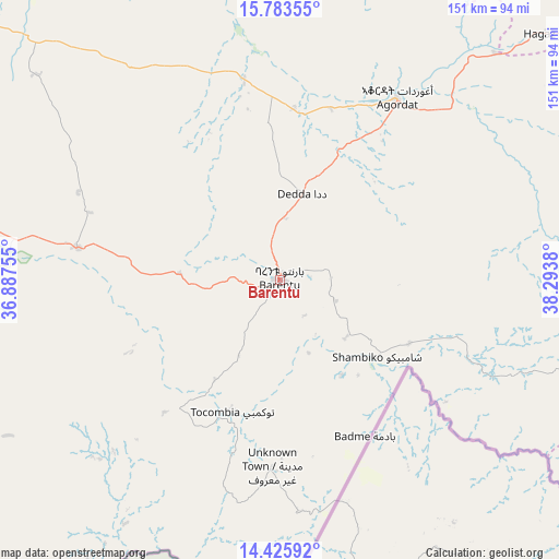
Barentu GPS coordinates[2]
15° 6' 20.952" North, 37° 35' 26.412" East
| Map corner | latitude | longitude |
|---|---|---|
| Upper-left | 15.78355°, | 36.88755° |
| Center: | 15.10582°, | 37.59067° |
| Lower-right: | 14.42592°, | 38.2938° |
| Map W x H: | 151×151 km | = 93.8×93.8mi |
| max Lat: | 15.77792° ⇑50% North |
| Barentu: | 15.10582° |
| min Lat: | ⇓50% South 13.00917° |
| min Long | Barentu | max Long |
| 36.6575° | 37.59067° | 42.73944° |
| W 8.3%⇐ | ⇒91.7% E |
Elevation
Elevation of Barentu is 1009 m = 3310 ft, and this is 279.5 m = 917 ft below average elevation for this country.
| Max E: |
2528 m = 8294 ft | 58.3% |
| Avg. | 1288.5 m = 4227 ft | |
| Barentu | 1009 m = 3310 ft | |
Min E: |
7 m = 23 ft | 41.7% |
See also: Eritrea elevation on elevation.city.
Geographical zone
Barentu is located in North Torrid zone (between Equator and Tropic of Cancer). Distance of this Northern Tropic circle is 926.3 km =575.6 mi to North.| Distance of | km | miles | from Barentu |
|---|---|---|---|
| North Pole | 8327.5 | 5174.5 | to North |
| Arctic Circle | 5721.6 | 3555.2 | to North |
| Tropic Cancer | 926.3 | 575.6 | to North |
| Equator | 1679.6 | 1043.7 | to South |


Nearby cities:
10 places around Barentu: (largest is in red/bold)
• Adi Keyh
194.1 km =120.6 mi,  98°
98°
• Ak’ordat
58.3 km =36.2 mi,  32°
32°
• Asmara
146.2 km =90.8 mi,  79°
79°
• Dek’emhāre
156.5 km =97.2 mi,  91°
91°
• Keren
118.7 km =73.8 mi,  50°
50°
• Mai-Mne
115.6 km =71.8 mi,  122°
122°
• Massawa
209.6 km =130.2 mi,  74°
74°
• Mendefera
133.8 km =83.1 mi, 100°
• Quandeba
145.2 km =90.2 mi, 72°
• Teseney
100.2 km =62.3 mi,  270°
270°
Sources, notices
• [Note1] Compared only with cities in Eritrea existing in our database
• [Src1] Map data: © OpenStreetMap contributors (CC-BY-SA)
• [Src2] Other city data from geonames.org with taken over terms of usage.
• [Src3] Geographical zone / Annual Mean Temperature by Robert A. Rohde @ Wikipedia
