Massawa geodata
Massawa (Northern Red Sea) is a seat of a first-order administrative division; located in Eritrea in Africa/Asmara (GMT+3) time zone. With population of 23,100 people, there are 2 cities with bigger population in this country. Compared to other cities in Eritrea, 91.7% of cities are located further ↓South; 83.3% of cities are located further ←West and 91.7% of cities have higher elevation than Massawa. Note1


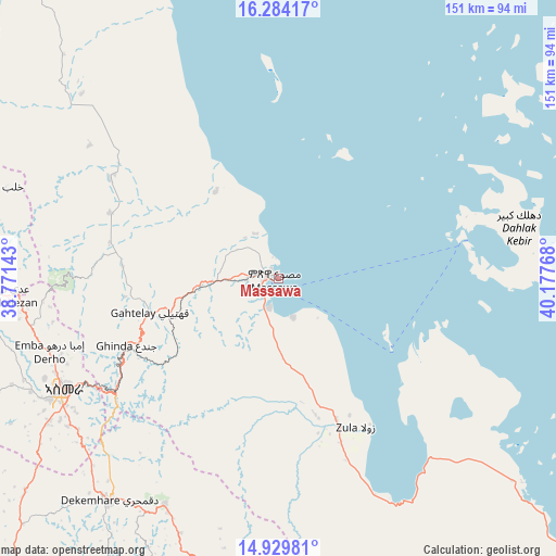
Massawa GPS coordinates[2]
15° 36' 29.196" North, 39° 28' 28.38" East
| Map corner | latitude | longitude |
|---|---|---|
| Upper-left | 16.28417°, | 38.77143° |
| Center: | 15.60811°, | 39.47455° |
| Lower-right: | 14.92981°, | 40.17768° |
| Map W x H: | 150.6×150.6 km | = 93.6×93.6mi |
| max Lat: | 15.77792° ⇑8.3% North |
| Massawa: | 15.60811° |
| min Lat: | ⇓91.7% South 13.00917° |
| min Long | Massawa | max Long |
| 36.6575° | 39.47455° | 42.73944° |
| W 83.3%⇐ | ⇒16.7% E |
Elevation
Elevation of Massawa is 9 m = 30 ft, and this is 1279.5 m = 4198 ft below average elevation for this country.
| Max E: |
2528 m = 8294 ft | 91.7% |
| Avg. | 1288.5 m = 4227 ft | |
| Massawa | 9 m = 30 ft | |
Min E: |
7 m = 23 ft | 8.3% |
See also: Eritrea elevation on elevation.city.
Geographical zone
Massawa is located in North Torrid zone (between Equator and Tropic of Cancer). Distance of this Northern Tropic circle is 870.5 km =540.9 mi to North.| Distance of | km | miles | from Massawa |
|---|---|---|---|
| North Pole | 8271.6 | 5139.7 | to North |
| Arctic Circle | 5665.7 | 3520.5 | to North |
| Tropic Cancer | 870.5 | 540.9 | to North |
| Equator | 1735.5 | 1078.4 | to South |


Nearby cities:
11 places around Massawa: (largest is in red/bold)
• Adi Keyh
85.6 km =53.2 mi,  187°
187°
• Ak’ordat
170.6 km =106 mi,  267°
267°
• Asmara
65.5 km =40.7 mi,  242°
242°
• Barentu
209.6 km =130.2 mi,  254°
254°
• Dek’emhāre
75.3 km =46.8 mi,  217°
217°
• Edd
302.8 km =188.2 mi,  128°
128°
• Keren
111.2 km =69.1 mi,  279°
279°
• Mai-Mne
156.9 km =97.5 mi, 221°
• Mendefera
106.9 km =66.4 mi, 221°
• Quandeba
64.8 km =40.3 mi,  260°
260°
• Teseney
307.1 km =190.8 mi, 259°
Sources, notices
• [Note1] Compared only with cities in Eritrea existing in our database
• [Src1] Map data: © OpenStreetMap contributors (CC-BY-SA)
• [Src2] Other city data from geonames.org with taken over terms of usage.
• [Src3] Geographical zone / Annual Mean Temperature by Robert A. Rohde @ Wikipedia
