Asmara geodata
Asmara (Maekel) is a capital of a political entity; located in Eritrea in Africa/Asmara (GMT+3) time zone. With population of 563,930 people, there are 0 cities with bigger population in this country. Compared to other cities in Eritrea, 66.7% of cities are located further ↓South; 58.3% of cities are located further ←West and 83.3% of cities have lower elevation than Asmara. Note1


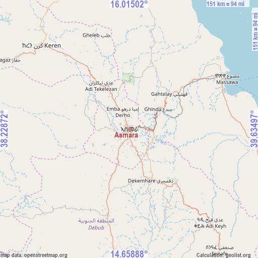
Asmara GPS coordinates[2]
15° 20' 16.98" North, 38° 55' 54.624" East
| Map corner | latitude | longitude |
|---|---|---|
| Upper-left | 16.01502°, | 38.22872° |
| Center: | 15.33805°, | 38.93184° |
| Lower-right: | 14.65888°, | 39.63497° |
| Map W x H: | 150.8×150.8 km | = 93.7×93.7mi |
| max Lat: | 15.77792° ⇑33.3% North |
| Asmara: | 15.33805° |
| min Lat: | ⇓66.7% South 13.00917° |
| min Long | Asmara | max Long |
| 36.6575° | 38.93184° | 42.73944° |
| W 58.3%⇐ | ⇒41.7% E |
Elevation
Elevation of Asmara is 2334 m = 7657 ft, and this is 1045.5 m = 3430 ft above average elevation for this country.
| Max E: |
2528 m = 8294 ft | 16.7% |
| Asmara | 2334 m 7657 ft | |
| Avg. | 1288.5 m = 4227 ft | |
Min E: |
7 m = 23 ft | 83.3% |
See also: Asmara elevation on elevation.city.
Geographical zone
Asmara is located in North Torrid zone (between Equator and Tropic of Cancer). Distance of this Northern Tropic circle is 900.5 km =559.5 mi to North.| Distance of | km | miles | from Asmara |
|---|---|---|---|
| North Pole | 8301.6 | 5158.4 | to North |
| Arctic Circle | 5695.7 | 3539.1 | to North |
| Tropic Cancer | 900.5 | 559.5 | to North |
| Equator | 1705.4 | 1059.7 | to South |


Nearby cities:
11 places around Asmara: (largest is in red/bold)
• Adi Keyh
72.8 km =45.2 mi,  138°
138°
• Ak’ordat
114.8 km =71.3 mi,  281°
281°
• Barentu
146.2 km =90.8 mi,  259°
259°
• Dek’emhāre
32.3 km =20.1 mi,  157°
157°
• Edd
335.8 km =208.7 mi,  117°
117°
• Keren
71 km =44.1 mi,  313°
313°
• Mai-Mne
98.6 km =61.3 mi,  207°
207°
• Massawa
65.5 km =40.7 mi,  62°
62°
• Mendefera
51.7 km =32.1 mi,  194°
194°
• Quandeba
19.9 km =12.4 mi,  343°
343°
• Teseney
245.3 km =152.4 mi, 264°
Sources, notices
• [Note1] Compared only with cities in Eritrea existing in our database
• [Src1] Map data: © OpenStreetMap contributors (CC-BY-SA)
• [Src2] Other city data from geonames.org with taken over terms of usage.
• [Src3] Geographical zone / Annual Mean Temperature by Robert A. Rohde @ Wikipedia
