Adi Keyh geodata
Adi Keyh (Debub) is a populated place; located in Eritrea in Africa/Asmara (GMT+3) time zone. With population of 13,061 people, there are 6 cities with bigger population in this country. Compared to other cities in Eritrea, 75% of cities are located further ↑North; 75% of cities are located further ←West and 91.7% of cities have lower elevation than Adi Keyh. Note1


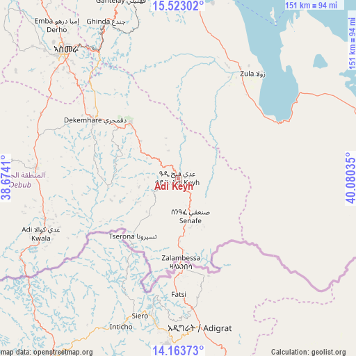
Adi Keyh GPS coordinates[2]
14° 50' 39.984" North, 39° 22' 37.992" East
| Map corner | latitude | longitude |
|---|---|---|
| Upper-left | 15.52302°, | 38.6741° |
| Center: | 14.84444°, | 39.37722° |
| Lower-right: | 14.16373°, | 40.08035° |
| Map W x H: | 151.1×151.1 km | = 93.9×93.9mi |
| max Lat: | 15.77792° ⇑75% North |
| Adi Keyh: | 14.84444° |
| min Lat: | ⇓25% South 13.00917° |
| min Long | Adi Keyh | max Long |
| 36.6575° | 39.37722° | 42.73944° |
| W 75%⇐ | ⇒25% E |
Elevation
Elevation of Adi Keyh is 2391 m = 7844 ft, and this is 1102.5 m = 3617 ft above average elevation for this country.
| Max E: |
2528 m = 8294 ft | 8.3% |
| Adi Keyh | 2391 m 7844 ft | |
| Avg. | 1288.5 m = 4227 ft | |
Min E: |
7 m = 23 ft | 91.7% |
See also: Eritrea elevation on elevation.city.
Geographical zone
Adi Keyh is located in North Torrid zone (between Equator and Tropic of Cancer). Distance of this Northern Tropic circle is 955.4 km =593.7 mi to North.| Distance of | km | miles | from Adi Keyh |
|---|---|---|---|
| North Pole | 8356.5 | 5192.5 | to North |
| Arctic Circle | 5750.6 | 3573.3 | to North |
| Tropic Cancer | 955.4 | 593.7 | to North |
| Equator | 1650.5 | 1025.6 | to South |


Nearby cities:
12 places around Adi Keyh: (largest is in red/bold)
• Ak’ordat
178.4 km =110.9 mi,  296°
296°
• Asmara
72.8 km =45.2 mi,  318°
318°
• Assab
416.3 km =258.7 mi,  119°
119°
• Barentu
194.1 km =120.6 mi,  278°
278°
• Dek’emhāre
43.4 km =27 mi,  305°
305°
• Edd
269.4 km =167.4 mi,  112°
112°
• Keren
143.7 km =89.3 mi, 316°
• Mai-Mne
99.4 km =61.8 mi,  251°
251°
• Massawa
85.6 km =53.2 mi,  7°
7°
• Mendefera
60.6 km =37.7 mi,  274°
274°
• Quandeba
91.3 km =56.7 mi, 324°
• Teseney
293.6 km =182.4 mi, 275°
Sources, notices
• [Note1] Compared only with cities in Eritrea existing in our database
• [Src1] Map data: © OpenStreetMap contributors (CC-BY-SA)
• [Src2] Other city data from geonames.org with taken over terms of usage.
• [Src3] Geographical zone / Annual Mean Temperature by Robert A. Rohde @ Wikipedia
