Mendefera geodata
Mendefera (Debub) is a seat of a first-order administrative division; located in Eritrea in Africa/Asmara (GMT+3) time zone. With population of 17,781 people, there are 4 cities with bigger population in this country. Compared to other cities in Eritrea, 66.7% of cities are located further ↑North; 58.3% of cities are located further →East and 66.7% of cities have lower elevation than Mendefera. Note1


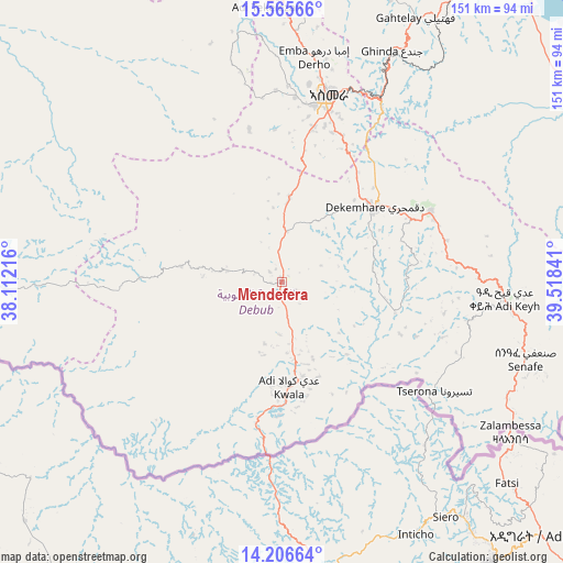
Mendefera GPS coordinates[2]
14° 53' 13.992" North, 38° 48' 55.008" East
| Map corner | latitude | longitude |
|---|---|---|
| Upper-left | 15.56566°, | 38.11216° |
| Center: | 14.88722°, | 38.81528° |
| Lower-right: | 14.20664°, | 39.51841° |
| Map W x H: | 151.1×151.1 km | = 93.9×93.9mi |
| max Lat: | 15.77792° ⇑66.7% North |
| Mendefera: | 14.88722° |
| min Lat: | ⇓33.3% South 13.00917° |
| min Long | Mendefera | max Long |
| 36.6575° | 38.81528° | 42.73944° |
| W 41.7%⇐ | ⇒58.3% E |
Elevation
Elevation of Mendefera is 1977 m = 6486 ft, and this is 688.5 m = 2259 ft above average elevation for this country.
| Max E: |
2528 m = 8294 ft | 33.3% |
| Mendefera | 1977 m 6486 ft | |
| Avg. | 1288.5 m = 4227 ft | |
Min E: |
7 m = 23 ft | 66.7% |
See also: Eritrea elevation on elevation.city.
Geographical zone
Mendefera is located in North Torrid zone (between Equator and Tropic of Cancer). Distance of this Northern Tropic circle is 950.6 km =590.7 mi to North.| Distance of | km | miles | from Mendefera |
|---|---|---|---|
| North Pole | 8351.8 | 5189.6 | to North |
| Arctic Circle | 5745.9 | 3570.3 | to North |
| Tropic Cancer | 950.6 | 590.7 | to North |
| Equator | 1655.3 | 1028.6 | to South |


Nearby cities:
11 places around Mendefera: (largest is in red/bold)
• Adi Keyh
60.6 km =37.7 mi,  94°
94°
• Ak’ordat
124.1 km =77.1 mi,  306°
306°
• Asmara
51.7 km =32.1 mi,  14°
14°
• Barentu
133.8 km =83.1 mi,  280°
280°
• Dek’emhāre
32.2 km =20 mi,  50°
50°
• Edd
327.7 km =203.6 mi,  108°
108°
• Keren
106.5 km =66.2 mi,  338°
338°
• Mai-Mne
50 km =31.1 mi,  222°
222°
• Massawa
106.9 km =66.4 mi,  41°
41°
• Quandeba
69.5 km =43.2 mi, 5°
• Teseney
233.1 km =144.8 mi, 276°
Sources, notices
• [Note1] Compared only with cities in Eritrea existing in our database
• [Src1] Map data: © OpenStreetMap contributors (CC-BY-SA)
• [Src2] Other city data from geonames.org with taken over terms of usage.
• [Src3] Geographical zone / Annual Mean Temperature by Robert A. Rohde @ Wikipedia
